Random Photos: The Wonderland Parking Lot
I’ve been up on the roof of the Wonderland parking lot once before, but that time I only took a picture of the view of the beach. Yesterday I went up there again, and took a few more pictures, because it’s a really awesome view.
 |
| Panorama! |
 |
| Looking down a curvy road. |
 |
| The view of the skyline wasn’t actually that good. |
 |
| These were all over the station. I don’t even know what they were! |
Random Photos: View From the 111
I remarked in my 111 post that there’s probably a really nice view of Boston from the Tobin Bridge. I managed to snap a picture of it on my hybrid bus ride, and it is indeed a fantastic view.
 |
| Not a great picture, but it was the best I could do. |
Random Photos: Could Use a Paint Job
 |
| It couldn’t hurt… |
A Ride on a New Hybrid Bus!
These new buses are so cool! They’re all big and round! They’re so quiet! Some of the LED lights turn off whenever the doors close! The seats are amazingly comfortable! The automatic announcements are so clear! It’s amazing! You should ride one! They run on the 111! Which is also a route worth riding! Score!
 |
| I didn’t get on this bus because it seemed too crowded. Little did I know that it was the only one running that day, so I had to wait for it to come back to Haymarket. |
 |
| A comparison shot. If there’s one thing I don’t like about the new buses, it’s the fact that the destination boards can be hard to read because of the sun reflecting off of them. |
 |
| Pretty futuristic! |
 |
| I love these new stop request buttons! There’s also tape, as seen in the background. |
 |
| All the new buses have security cameras like those on some of the existing fleet. |
 |
| The windows were already really scuffed up. |
 |
| The chairs are really, really comfortable. And single seats are back!!! |
 |
| I got off at Bellingham Square. |
 |
| Bye! |
86 (Sullivan Square Station – Reservoir (Cleveland Circle) via Harvard/Johnston Gate)
Pre-blog, there were a few buses that my father and I took for fun. Some of these were used for the first posts (459, 30), but many ended up being forgotten. The 86 was one of those original buses, and I’ve actually used it a few times since then on the Sullivan-Harvard portion. Finally, in August, I took the whole thing, and yet I still kept putting the review off. But now, for the 250th post, let’s finally take a look at the 86. This is probably one of the most diverse routes on the MBTA, running from posh Cleveland Circle to Harvard University to industrial Sullivan Square. It makes for quite an interesting ride.
 |
| That guy in the bottom left looks pretty goofy. |
We went by the massive Harvard Stadium as well as some university buildings, then crossed over the Charles River. The North Harvard Street bridge is being worked on, so there’s usually quite a bit of traffic. Luckily, the 86 made it over without a hitch, and we turned onto Eliot Street. There were quite a lot of businesses here, being Harvard Square.
 |
| A nice view from the bridge. |
Now, Cleveland Circle-bound 86 buses go right through the heart of the square, but Sullivan Square-bound trips go through the bus tunnel instead. So, we turned onto Bennett Street, University Street, and Mount Auburn Street before heading into the tunnel. I would imagine that this is a much faster route than what Cleveland Circle-bound riders have to deal with, since they go right through the traffic-ridden square.
Leaving the tunnel, we bypassed the Dawes Island stop (which only Cleveland Circle-bound buses use), looped around the busway portal, and headed into the Cambridge Street tunnel. Coming out, we turned onto Quincy Street and went by a massive cathedral-esque building of which tourists love to take pictures.
We then turned onto Kirkland Street, passing a really out of place apartment building, and then some beautiful houses in a leafy neighborhood. There were some businesses at the intersection with Beacon Street, then Kirkland became Washington. This was where the atmosphere changed from a more suburban feel to closely-spaced Somerville apartments. Not that I don’t love the latter kind of neighborhood.
There was a school, and immediately after we crossed over the Commuter Rail tracks and entered Union Square. There were, of course, a lot of businesses here, and a few bus connections. Washington Street merged into Somerville Ave and then made a left turn, where we were joined by the 91. Going under the McGrath Highway and some more tracks, it started to feel kind of industrial. Washington Street became Cambridge Street as we entered into Boston, and then we pulled into the Sullivan Square busway.
 |
| Since the first picture was so bad and my bus flashed NOT IN SERVICE immediately upon coming into Sullivan, I decided to wait for the next bus to get a decent picture. |
Route: 86 (Sullivan Square Station – Reservoir (Cleveland Circle) via Harvard/Johnston Gate)
Ridership: Very high – 52 people! And it was a Saturday! Some people used it for crosstown connections, and others used it just for local service, but nobody went from beginning to end…except me.
Pros: This is a fantastic crosstown route, connecting to three out of four subway lines. It seems to get very high ridership, which is also good. The route is about half-and-half in terms of unique portions, which means that there are plenty of bus connections, but also parts that just the 86 serves. This bus also has a pretty good schedule: every 10 minutes rush hour, every 20 minutes during the day, every half hour Saturdays, and every 35 minutes nights and Sundays.
Cons: I wish the bus was consistent about its route through Harvard, preferably going via the bus tunnel. It can be really confusing for those who haven’t taken the bus before.
Nearby and Noteworthy: This bus goes by many businesses, none of which I know anything about. As usual.
Final Verdict: 8/10
This is a great crosstown route with a pretty good schedule (especially for a non-Key Bus Route). My only problem is the route it takes in Harvard Square. My personal opinion is that they could route all trips through the busway to improve speed. The problem with this, though, is that it seems like buses can’t get into the busway from the Cambridge Street tunnel, so the intersection would have to be reconfigured. That would be a lot of work, so maybe just improving signage for Cleveland Circle-bound buses would be fine…
Latest MBTA News: Service Updates
The Fairmount Line is finally getting weekend service in a week’s time! Check the new schedule here. But more importantly, to me, anyway, is that this is the 250th post! The blog’s been experiencing a lot of growth, both in terms of followers, and evidently in content. These posts have just flown by, and I look forward to writing many more to come…
51 (Cleveland Circle – Forest Hills Station via Hancock Village)
If I were to ask you if Brookline has good public transit access, you would probably say yes. After all, it has three Green Line branches serving it, providing frequent service to some pretty dense apartments. Yes, the northern part of Brookline gets pretty good coverage. But what about the part south of the D? The part with the grand estates, the huge yards, and the many forests and golf courses? This barren part of Brookline has only one single bus to serve its entirety: the 51.
 |
| This was back when the trees were green. |
It all started at Forest Hills, way back in August (it took me a while to get around to reviewing this). After picking people up there, we headed down Washington Street along with a multitude of other routes. There were some nice apartments along here, with a few businesses. At Roslindale Square, we turned onto South Street, going by the Commuter Rail station, as well as a lot of commercial buildings.
We then left the other buses by going down Robert Street, and then turning onto Walter Street. which was residential. Eventually it became sort of a rural feel, as we were right next to the Arnold Arboretum. We turned onto Weld Street, which also felt rural until the intersection with Center Street, where there were some businesses.
Weld Street was residential again after that, as well as curvy. We were on it for quite a while until finally, we turned onto Corey Street and then the wide, tree lined VFW Parkway. It was a pretty beautiful street, but we soon turned onto Independence Drive at a small mall. We then went through (shudder) Hancock Village, a (groan) development where all the houses are the same. This is also where we entered Brookline.
Independence Drive became Grove Street, and luckily the houses became normal again. There was a line of businesses at Putterham Circle, then Grove Street became Newton Street and it felt rural again. We turned onto Clyde Street, which became Lee Street, and we went by some pretty impressive mansions.
 |
| An obstructed view of the Brookline Reservoir. |
Lee Street then curved to the left and we went by the Brookline Reservoir. We were on Route 9 for only a block before we turned onto Chestnut Hill Ave. The houses were much smaller and closer along here, a big contrast from the huge mansions from earlier. But we never made it to the apartments of Beacon Street, for we had to pull into the Reservoir busway.
 |
| There are a few people going back to Forest Hills. |
Route: 51 (Cleveland Circle – Forest Hills Station via Hancock Village)
Ridership: There were a little over 20 people who used this bus on a Saturday. That’s not that bad, honestly. Everyone who got on at Forest Hills got off at certain points along the route and everyone who got on at certain points went all the way to Cleveland Circle.
Pros: It serves a massive swath of Brookline that has no other public transit options. That said, I’m sure many of those mansion dwellers have cars, but over 20 people on a Saturday isn’t bad.
Cons: The schedule is pretty poor: every 25 minutes rush hour, every hour during the day and night, every hour and five minutes on Saturdays, and no service on Sundays. The route could also stand to be a little less circuitous. It makes a rather inefficient U shape near Forest Hills and Roslindale.
Nearby and Noteworthy: If you like gawking at mansions, then this is your bus! It does go through Roslindale, though, which has a lot of businesses.
Final Verdict: 5/10
This is really the only public transit available for much of Brookline, so I can’t lower its score too much. But the schedule is pretty awful, and I don’t like the U shape the route makes. Considering that no one got on or off in Roslindale on my ride (and the fact that there are a plethora of other buses that go there), perhaps the route could bypass it entirely by going through the Arnold Arboretum…
You can see how buses would travel faster with this new route. The question is if it’s necessary or not. Much of the current route is served by other buses, but there’s a short section on Walter Street that’s just the 51. So rerouting this bus might not bode well for the folks in that neighborhood. Seems like a mixed bag, I suppose.
Latest MBTA News: Service Updates
The MBTA has given Keolis (the new operator of the Commuter Rail) a fine of $434,000 for late trains alone, and $804,000 in total! Apparently Keolis isn’t doing the best job at keeping the Commuter Rail on schedule.88
Sneak-Peek of the 211
When I hopped on the 211, I didn’t realize that the bus takes a different route on Sundays. Instead of taking its normal way south of North Quincy, it replaces the 212 on Billings Road. Thus, I decided not to give the 211 a proper review, since A) I haven’t been on a part unique to that bus, so the review would be incomplete, and B) Reviewing the 211 now would make riding the 212 obsolete. So, I decided to hold off. But there were still some very nice views on the ride to Squantum, so consider this a “sneak-peek” for when I get around to riding this bus on a weekday.
 |
| Fall foliage. |
 |
| Some marshland. |
 |
| And some more. |
 |
| The Boston skyline! You can also see the JFK Library in the foreground. |
 |
| The sea is visible in the distance. |
 |
| The skyline, with Back Bay. |
 |
| Dorchester. |
 |
| A close-up of downtown. |
201/202 (Fields Corner or North Quincy Station – Fields Corner via Neponset Ave and Adams Street)
Perhaps the MBTA needs to hire some new map makers, because even after riding the 201 and 202, I still can’t make heads or tails of the routes’ map. To me at least, it just looks like a mess of arrows pointing in random directions. And there are some really misleading bits, like how it shows the 201 bypassing the Keystone Apartments when it actually serves them, at least sometimes. Certain trips. But the 202 bypasses them sometimes, too. Okay, maybe it’s the routes that are insanely confusing, not just the map.
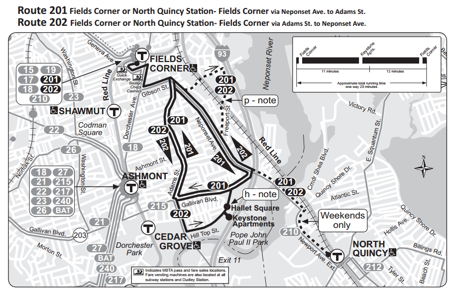 |
| Yup, makes perfect sense. |
On weekdays, the 201 and 202 form clockwise and counterclockwise loops (respectively) to and from Fields Corner. But on weekends, they form a direct link from North Quincy to Fields Corner, with the route they take corresponding to the direction the bus would normally go around the loop…it’s pretty confusing.
 |
| There’s some nice fall foliage in the background. |
Anyway, a 201 arrived at North Quincy, and we made our way to Hancock Street. There was a bridge over the Neponset River, then we went around Neponset Circle and down Gallivan Boulevard. The street had a lot of ugly businesses with massive parking lots, then we turned onto Hallet Street, which felt more industrial. We went into the Keystone Apartments parking lot slowly (stupid speed bumps), but nobody got off or on. Then we headed back towards Neponset Circle and onto Neponset Ave.
 |
| Nice view from the Hancock Street bridge. |
There were some businesses along here, then it got more residential. Some trips go up Freeport Street to serve the Puritan Mall. but we just continued down Neponset Ave, where there were some closely-spaced houses. Occasionally there would be a few businesses but it was mostly residential. Neponset Ave became Adams Street, but right after that we turned onto Gibson Street, which had some nice apartments (and a not-so-nice public works department).
We then turned onto Dorchester Ave, and then again into the Park Street busway. I’m surprised that they actually put a busway here, considering how close to Fields Corner it is. There were some businesses here, as well as a mall. We went up Geneva Ave, then onto another busway that for some reason went right next to Fields Corner without any stops. The busway made a u-turn around the station, and the actual stop was on the other side.
 |
| No Quincy Station? What happened to it? |
Now we were a 202, but we headed back the same way as before, via Geneva Ave, the Park Street busway, and Gibson Street. But instead of going down Neponset Ave like before, we used Adams Street, which had some apartments that eventually became houses. It continued like this for a while until near Gallivan Boulevard, when it suddenly became all businesses.
We continued onto Granite Ave, which was residential. I could see the bridge that the 215 uses to get over the Neponset River, but we turned off just before it onto Hill Top Street. There was a nice park on one side of the street with a playground and houses on the other. Soon we went back into the Keystone Apartments parking lot, actually picking someone up this time, then went back up Hallet Street.
 |
| Interesting view in the Keystone Apartments parking lot. |
We made our way over the bridge again, then turned onto Newport Ave Extension. We went through the massive office park, as mentioned in the North Quincy review, and then past a marsh. Turning onto West Squantum Street, we drove over the Red Line tracks and into the North Quincy busway. Mission accomplished.
 |
| Nice view! |
Routes: 201/202 (Fields Corner or North Quincy Station – Fields Corner via Neponset Ave and Adams Street)
Ridership: It was pretty quiet, being a Sunday. There were exactly eight people who rode in each direction, many using the route for local service. Fields Corner and North Quincy, the two subway connections, weren’t that busy, with only a few people getting on and off at each.
Pros: The two routes serve that awkward area in between the Ashmont and Braintree branches. It’s nice that buses go in both directions on the loop, so people don’t have to take really circuitous trips like they might if the loop was one way. The 201 provides most morning rush hour service, while the 202 covers the evening rush; both go about every 15 minutes during those periods, which is pretty good. Midday is about every 20 minutes between the routes, and night service is every half hour, provided exclusively by the 201, until 1 in the morning. On Saturdays, the routes run about every 25 minutes together. So overall, not a bad schedule. I also had a really nice driver, whom I was talking to throughout the entire ride, but that doesn’t affect the score of these routes.
Cons: Sunday service is every 45 minutes, which isn’t great, but there wasn’t enough ridership to justify higher frequencies. I also wish the routes were more decisive about whether they want to serve North Quincy or not. It would be nice if it was more consistent, and I think it’s a decision that wouldn’t affect ridership too much. My main issue is that these routes seem way more confusing than they have to be. I don’t know whether it’s the routes themselves or just the way they’re drawn on the map, but something has to be done about this. Perhaps a map redesign is in order…
Nearby and Noteworthy: There were a few businesses along the route, the most prominent of which being at the intersection of Adams Street and Gallivan Boulevard.
Final Verdict: 7/10
Honestly, I thought I would be giving these a much lower score when I started this review. But it turns out that these buses are pretty good after all. They serve what they need to serve, and get the job done with fairly frequent service. But really, someone has to take a stab at making that map less confusing.
Latest MBTA News: Service Updates
GUEST POST: 64 (Oak Square – University Park, Cambridge or Kendall/MIT via North Beacon Street)
Ever since I first saw the 64, I’ve always wanted to ride it. Why? I don’t know, but I heard that this bus takes the craziest streets. So I decided to ride down to Kendall/MIT to see how crazy this route is.
The Ride: In order for me to go all the way to Kendall/MIT, I had to wake up at around 7 on a Friday morning. This is because during midday, evenings, and all day on the weekends, the 64 ends at University Park located about a mile away from Central Square in Cambridge, even though the destination display states that it ends at Central Square. (Kind of misleading, don’t you think?)
this the craziest route!)
The route started to get interesting when the bus started picking up speed down Birmingham Parkway which then becomes North Beacon Street. Now we headed down past Market Street where passengers can connect to the 86 and from Market Street the bus is supposed to turn on Life Street according to the map I looked at. But when I asked the driver he said that there was construction and so he couldn’t turn down Life Street making angry customers who wanted the stop by Stop & Shop even angrier. We then headed on Cambridge Street in Union Square (Not the one in Somerville!) where we picked up and dropped off several people. After we left Union Square the trip was pretty quiet as we crossed the Mass Pike and the Charles River into Cambridge. We then made a series of turns onto some more crazy side streets. Finally after a very long 20 minutes of sitting in traffic the bus finally pulled up to Central Square.
Now from here the bus would make a right on Mass. Ave to continue to University Park, but like I said earlier the bus continues to Kendall/MIT on weekdays. So we followed a 83 and a 91 bus down Prospect Street then made a right on Broadway following a 68 bus, and after an additional 10 minutes of traffic we finally arrived at our final destination: Kendall/MIT.
Fleet: Well, I know the 64 is dispatched from Charlestown so expect to see some RTS’s, New Flyer D40LF, and on some rare occasions a Neoplan AN440LF, but in the future I hope that I will see some XDE40’s on this route.
Final Verdict: After re-reading this entire review I figure that I give this route a 7.5/10 because I think although the ridership can be crazy and the route itself can be even crazier, I think in my opinion this route is a very fun route and I would recommend it.
North Quincy
The first thing you notice when going to North Quincy is just how long it takes to get there. From here to JFK/UMASS is seven minutes by train, and it’s the longest distance between stations on the system at a little over 3 and a half miles. The station has a very isolated, park-and-ride feel to it in general, and you have to walk a bit to get to civilization. There is a nice view just before the platform, though, where the train crosses over the Neponset River.
 |
| As usual, the view is not captured well. |
The platform itself is really…meh. The architecture just feels bland. I do like the glass waiting rooms, though. On one side of the platform there are some trees blocking the parking lot, while on the other side, beyond the Commuter Rail tracks, there’s a big parking garage that didn’t seem to be open (more on that in a sec).
 |
| Like I said, meh. The MBTA didn’t even bother to change the maps here to the new one. |
In between the station and a large expanse of marshland is a pretty big office park. To be perfectly honest, it looks like it has more parking than anyone would ever need, yet there’s still the aforementioned garage next to the platform. In fact, a sorry-looking exit to the garage exists on the western side of the station. It’s closed on weekends, though, as a guy I saw found out the hard way.
 |
| It’s such a weird exit! |
Since it was a Sunday, I of course had to use the main exit, which was actually kinda nice. I liked how open and modern it felt. Unfortunately, I didn’t get to try out the elevator, but there is one. There’s only one escalator, though, and that’s going up. It’s kind of annoying, but I can live with it.
 |
| I don’t know why there’s a random traffic cone, though. |
There’s not really much mezzanine to speak of here. It’s just a narrow hallway with a few fare machines and a few fare gates. It feels kind of bleak, even with a sizeable window at one end. There’s also a fan, which is probably nice during the summer, but not so much now.
 |
| Pretty dark in here. |
The busway is pretty boring, too, but also straightforward. The latter is probably because there are only seven buses that serve the station: two only have one trip here (the 215 and 217), two only come on weekends (the 201 and 202), the 210 and 212 don’t have Sunday service, and the 211 is the only one that comes seven days a week. One thing I do love about the busway is the presence of a countdown clock: that way you know if you should rush for your train or if it’s not worth it. This is a “screw you” station, being above ground and all (meaning you can see the train stopped at the platform but know you won’t make it).
 |
| The busway, with some vending machines and bike spaces. |
There seemed to be a constant line of cabs waiting to pick people up here. I only saw one person get into one during my half hour or so in the busway, so I’m not sure how much business the taxis actually get. The parking lot here is pretty huge: over 1200 spaces! I’m assuming people must use this station as a park-and-ride.
 |
| Not too many people here on a Sunday. |
The immediate surroundings of the station are pretty grim and absolutely not pedestrian-friendly. There’s a Walgreens across the street that, based on my experiences, doesn’t stock camera chargers. So, um, don’t go to the North Quincy Walgreens if you desire camera chargers. There are also some gas stations, a high school, and a McDonald’s right near the station.
 |
| The station, with an ugly-looking drive-through in the foreground. |
Other than that, the surroundings of the station are mostly residential. However, there is a little commercial area about a five minute walk away. It doesn’t look like anything that nice, but at least it’s something. I wouldn’t know, though, since I only went to the Walgreens.
 |
| It’s a 17 minute wait if you missed that train… |
Station: North Quincy
Ridership: As I said, this seems like a pretty big station for park-and-riders. Some people might commute here, too, because of the nearby office parks. And students might use it for the nearby high school. As for numbers, this station gets a little over 7,000 people per day, giving it the second-highest ridership on the Braintree branch.
Pros: I like the escalator all right; the presence of a countdown clock in the busway is convenient; the station has a lot of parking and a lot of ridership; and there’s some stuff to do nearby if you walk for a few minutes.
Cons: Okay, this whole station feels really dated and bleak. Pretty much everything about it except for the escalator leading up to the mezzanine looks really boring. And there’s only one escalator, but that’s only an annoyance. The bus connections are pretty grim, and the surrounding area is really not pedestrian friendly. Finally, this station is about a million miles away from JFK/UMASS. Imagine if they stuck a station in between the two, and had Braintree branch trains also stop at Savin Hill.
Nearby and Noteworthy: Probably best to walk to that aforementioned commercial area if you’re looking for something to do from here.
Final Verdict: 5/10
There’s a very dated feel about this entire station. A modern renovation would be really nice, if the MBTA could muster it. And imagine if they were to put a new station in between North Quincy and JFK/UMASS. Such as this possibility… (Yeah, I figured out how to put maps in!)
As you can see (you may have to zoom out a bit), this station is in the middle of a rotary. The 201 and 202 bus routes go right by, and the 210 is a few blocks away. The only problem with building this is that there might not be any room on the line for platforms. So I suppose that makes this a bust, then…
Latest MBTA News: Service Updates
23 (Ashmont Station – Ruggles Station via Washington St)
“How long is that bagel gonna take?” I asked my friend, Lucy.
 |
| The 23 from up above the busway. |
 |
| The picture doesn’t capture it very well, but you can see that rainbow gas tank from here (which is, apparently, the largest copyrighted piece of art in the world).. |
 |
| The bus turning to pick up people going back to Ruggles. |
43 (Ruggles Station – Park and Tremont Streets via Tremont Street)
The first time I took this bus (about seven months ago), it had been dark and thunderstorming. I remember people would run in and make comments about the awful weather as they paid their fares. I never gave the 43 a review, partly because I couldn’t see a thing out the window and partly because the pictures I took were terrible. But now, I’m giving this bus a second chance.
 |
| About halfway between Park Street and Boylston, a distance of about three inches. |
After getting on at Park Street, we headed down Tremont Street with the Boston Common on one side and tall buildings on the other. After stopping at Boylston, we entered the Theater District, where there are a lot of theaters. And more tall buildings. They got much shorter after a stop at Tufts Medical Center, though.
Tremont Street made a sharp turn to the right, then the left, and then we went over I-90. There was a nice view of the John Hancock and Prudential buildings from here. At this point the driver was making extensive use of the horn to let people know not to mess with us. There were some points when he was driving so recklessly it felt like we were going to crash into someone.
 |
| Bad picture, but nice view. |
I really love the South End. I don’t know if it’s the narrow streets or the old-fashioned architecture, but I love it. The architecture, at least, is very prominent along the next section of the 43. And what’s interesting is that there’s a point when you suddenly notice that the neighborhood isn’t all that nice anymore. All of a sudden there’s a lot more graffiti and the buildings seem to be newer and less charming. There is an abundance of gardens around here, though, so that’s good. Soon we turned onto Melnea Cass Boulevard, and then again into the Ruggles busway, where the bus changed its destination board to become a 15.
 |
| I love this one back at Park Street! |
Route: 43 (Ruggles Station – Park and Tremont Streets via Tremont Street)
Ridership: A grand total of four people, plus one child. That’s really bad, even for a Sunday. And the two other people (plus one child) only went for short distances, so for the most part it was just Lucy and I. (Yes, a friend came along! Hooray!) Even if people did ride, no one would ever have reason to take this from beginning to end, since the Orange Line goes from Ruggles to Downtown Crossing (which is part of a complex with Park Street) nice and quickly.
Pros: For one thing, this bus is fast (not as fast as the train, but still fast). Perhaps it’s because practically nobody rode it, but it only took us about 15 minutes to get from Park Street to Ruggles. This bus is also a nice halfway point between the Orange and Silver Lines, serving parts of the South End not covered by those. Finally, the 43 has a pretty awesome schedule: every 20 minutes Weekdays and Saturdays, and every 25 minutes Sundays.
Cons: We admittedly took this bus on a Sunday, so low ridership is to be expected. But four people (plus one child) is really terrible! Maybe it was because of the time of day, or perhaps the weather, but the ridership was very disappointing.
Nearby and Noteworthy: Lots of theaters and some neat architecture are what awaits you on this route.
Final Verdict: 8/10
This is a nice route if you need to get from one end of Tremont Street to the other, or even if you’re just too lazy to walk a few blocks. This is a bus that many people use for short distances, and it fits that niche well. A good schedule means there’s always a bus somewhat close by, though maybe it could stand to run a little less often based on the ridership we saw.
Latest MBTA News: Service Updates
The first of the new MBTA buses will hit the streets tomorrow (November 5) at Haymarket! I’m excited for when they get around to my neck of the woods; I want to see what they look like!
Kendall/MIT
I had to use Kendall to get to a job in late summer. I guess that technically makes this post “out of date,” but I can assure you that there haven’t been any astronomical changes here in the past three months. Just take my word for it.
Let’s start with the entrances, which are my least favorite part of the station. Aesthetically they’re fine, but you have to be very careful which one you go into; one wrong move and you could end up going somewhere you don’t want to. Yes, there are no crossovers here, so the entrances correspond to specific directions. Make sure you pay close attention to which way you go here.
 |
| Taken from across the street. |
The mezzanine is also pretty standard, nothing special. One thing of note is that the fare gates empty right onto the platform, making this a “screw you” station: the kind of station where you see a train waiting there with the doors open and you know you’re not gonna make it but you try to run for it anyway and end up wasting your breath… it happened to me, at least.
 |
| The mezzanine. |
The platform, although it has a few random pipes, is bright and clean. Looking in the distance, you can see the tunnel portal where the train goes over the Longfellow Bridge. There are also some interesting facts and timelines about the area on the walls. There’s so much information it almost makes you wish the train wasn’t coming in two minutes. It definitely softens the blow if you miss your train, this being a “screw you” station.
 |
| The platform. |
There’s no proper busway at Kendall, but that’s because the area is so dense. However, the bus connections themselves are pretty flimsy. There are four MBTA buses that run here, one of which only comes to Kendall during rush hours (the 64), and the other three are just weekdays (the 68, 85, and CT2). This is, however, also a stop on the E-Z ride service from North Station to Cambridgeport, and there’s that weird shuttle that goes to the Cambridgeside Galleria. So, I guess that ends the review. It’s been fun. See you next time.
Okay, you know I wouldn’t forget the best part about this station: the Kendall Band. The interactive art installation has had quite a history, which you can read about here. There’s only one operational instrument currently, which is a set of bells that are controlled by a lever. I always feel really awkward doing it when there are other people there (so always), but it’s still a really cool and unique feature of the MBTA.
 |
| Totally not blurry picture of a train coming in. |
Station: Kendall/MIT
Ridership: A lot of people commute into Kendall because of all the technology jobs in the area. Even on weekends Kendall is still somewhat busy. According to the 2010 Blue Book, it gets just shy of 14,000 people per weekday and is in the top 10 busiest stations on the system.
Pros: There’s a lot to like about this station: its location, its decent aesthetics, its timelines, and of course, the Band. Frankly, this station is worth coming to just for the latter, although keep in mind the lack of a free crossover. Speaking of which…
Cons: Yeah, the lack of a free crossover is really annoying. Also, the bus connections are lacking. Overall, though, there’s not that much to hate here.
Nearby and Noteworthy: Kendall Square has gotten very hip over the years, and has a lot of modern buildings and restaurants.
Final Verdict: 8/10
I thought I would have to subtract a lot of points for the crossover issue, but there’s so much to love about this station. The fact that neighboring Central also has no crossover makes it more of a problem, but what about the Kendall Band? I’ve never seen anything like it in any subway system, which alone makes Kendall worth visiting.
Latest MBTA News: Service Updates
It’s snowing outside as I write this, so it’s about that time to get educated on what to expect for winter weather on the T.
Courthouse
Okay, this station is absolutely beautiful. I think this is probably the flashiest, most modern, and – dare I say it – best looking station on the MBTA. Too bad it’s the second worst station on the system in terms of ridership. But for now, let’s forget about that and take a look at Courthouse.
 |
| One of those pointless Silver Line Way shuttles. |
The station has two entrances. The main one is on the south side of Seaport Boulevard, right next to some modern apartment blocks. The other entrance is by some parking lots and the station’s namesake, the John Joseph Moakly Courthouse. It’s also close to a lot of new buildings, thanks to the massive development boom in the Seaport District. Furthermore, this is the closest MBTA station to the ICA, which I feel should be better advertised. If the station were renamed “Courthouse/ICA,” would it get more ridership?
 |
| The smaller entrance, with the main one visible to the right. |
Descending down the staircase, you end up in possibly my favorite hallway ever. Purple and blue LED lights streak the ceiling. A subtle hourglass shape gives a very sleek look. Silver panels make up the big walls. Not to mention the numerous ads, but…shhh!
 |
| How can you not love this? |
The platform is also fantastic. You’ve got those silver panels again on the walls, some benches, some concrete pillars, and, when I was there, a random cherry picker. How do you even get a cherry picker down there? Can they not get it out? Who puts cherry pickers in subway stations anyway? For some reason there were a lot of MBTA workers at the station, and they made me feel really awkward when I took pictures. At least nobody yelled at me this time.
 |
| The weird cherry picker is off to the left. |
Station: Courthouse
Ridership: Do we have to talk about the ridership? This station is so awesome until we bring up the ridership. Sigh. It’s the second least used station on the subway system (excluding streetcar stops), with only 945 weekday boardings. But the station’s so nice…
Pros: Okay, this thing is beautiful. It really is. Like, this is probably worth seeing even if you’re not taking the bus. But you’ll probably see it if you decide to take public transportation to the ICA, because this station has a pretty good location.
Cons: The ridership is disappointingly small, but I think there’s a way to improve it somewhat…
Nearby and Noteworthy: The ICA is a pretty popular place and a great museum. I feel like this station could get more ridership if the MBTA added a “/ICA” to it.
Final Verdict: 7/10
It’s a beautiful station. And yes, that shouldn’t be the sole reason to like a station, but it’s really beautiful. And the location’s nice. You’ve got those apartment blocks, the newly developed buildings, the ICA, and of course, the courthouse. But the ridership is frustratingly low, and I think if the MBTA made it more obvious that this station is close to the ICA it could help.
Latest MBTA News: Service Updates
Belmont Center
You gotta love the architectural style of Belmont Center. According to good ol’ Wikipedia, it’s called “American Craftsman,” which was popular from the late 1800s to the 1930s. Yes, this building is pretty darn old. The building itself is now used by the Belmont Lions Club, which does things to help out the community.
 |
| You gotta love that building. |
Unfortunately, the platform itself isn’t anything special. The inbound side has the nice building, but there’s nothing much on the outbound side. The best “amenity” here is a wastebasket! What’s more, neither of the platforms have even an elevated portion for wheelchair users. There’s also no parking. And only eight bike spaces. Geez, this station’s lucky to have the wastebasket!
 |
| A train coming in. |
But there is another cool part of this station: it’s the tunnel between the two platforms. Sure, it may be really dingy, but it is absolutely covered in graffiti. I’m not sure if this was intentional or if people just spray painted it over time (because Belmont is such a ‘hood), but it looks pretty cool and colorful when you walk through. I do wish they lit it up better, though.
 |
| I don’t think I would want to walk through this at night. |
 |
| In terms of scenery this is the polar opposite of the Waltham picture. |