Random Photos: Bus Countdown Clock
 |
| It’s so shiny… but shiny apparently doesn’t mean functional. |
A Commuter Rail Ride From South Station to Ruggles
I had gotten a Zone 1A Commuter Rail ticket a while back, but I never actually used it. I decided to just keep it in case I ever needed to ride the Commuter Rail within Zone 1A. But the ticket was expiring on April 19, so I figured I would have to use it soon. So, I decided to go to South Station and grab the first train that comes (that’s how I roll).
 |
| The train at South Station. |
 |
| A bad picture of the inside of the train – it wasn’t too crowded yet. |
 |
| The train leaving Ruggles. |
 |
| A train going back towards South Station. |
Random Photos: The View From the Ruggles Parking Garage
I don’t believe Ruggles has an “official” parking garage, but there was one very close to it that apparently belongs to Northeastern University. I decided to head up to the roof to see what the view was like. I took a bunch of pictures, so I’m just going to run them all together. Which one’s your favorite?


Service Change: UMASS Boston Shuttle Route 1 (Again)
When I took the UMASS shuttle bus back in February, I really liked it, especially because of the amazing articulated buses used on the route. But Crystal Transport, the operator of the buses, recently failed a safety inspection as many of its drivers tested positive for drugs and alcohol. Now there are two companies running the buses: Paul Revere runs the 1 and 2, which connect to JFK/UMASS Station, and Academy Bus runs the 3, which goes to “Bayside,” wherever that is.
My father and I would be taking the Paul Revere buses, as we were going from JFK/UMASS to the JFK Library. I was pretty excited at first, as Paul Revere runs the fantastic 712/713 bus. But…we had some issues. We were already kind of late for the event, and so we planned to get the first bus that came. First, a Paul Revere bus entered the station, let a bunch of people out, then just left before anyone could get on. Way to make a first impression…
 |
| Stupid bus. |
Next an 8 came along. This one is actually the MBTA’s fault: we were about to get on the 8, as that goes to UMASS, too, and the driver asked us where we were going. “The JFK Library,” we responded. She told us to wait for a UMASS shuttle and drove off. Turns out the 8 actually stops at the library, but okay, fine. Then a weird coach bus came, and it was apparently going to UMASS. “Are you going to the JFK Library?” asked my father to that driver. “No,” he replied. “There should be a bus behind me going there.” Then he closed his doors and drove off. Well, there wasn’t a bus behind him, but another coach bus came a little later. This wasn’t going to the library either, but we figured we could walk from where it dropped us off.
 |
| This is a “special” bus, apparently. |
It was fairly nice inside, with big comfy seats. It was also really dark, though. I tried to turn on one of the lights at a seat (it’s like what you would find on an airplane), but it didn’t work. This seemed like a pretty ancient bus in general. There were really fat TV’s every few seats, but they weren’t showing anything. There was also a bathroom at the back, but I think people can probably hold it for a 5 minute ride.
 |
| The interior, from the back of the bus. |

 |
| I can’t resist disgusting bathrooms. |
 |
| Real cutting-edge technology here. |
The walk ended up being about five minutes, so…not that long. I was really disappointed with my experience with Paul Revere. I know Crystal’s drivers were drug addicts and drunkards, but they ran the buses much better than this. I know Paul Revere just started the service, but I really hope it gets better. And we saw an Academy bus running on Route 3 – it looked so much nicer, with electronic destination boards and everything. And the 3 is the one with the lowest ridership, to my understanding. Hey, maybe Paul Revere and Academy should just switch…
| I don’t know why it says “Charter,” but the point still stands that this bus is nicer. |
Random Photos: Thanks, MBTA!
You probably remember my post about the MBTA’s online map, and how they said they would fix it. They did, and it’s so much better now. But a few days ago, the person on the MBTA who I was corresponding with said they wanted to send me a “mailed thank you.” I was expecting some sort of CVS greeting card, but two days later a package arrived for me marked “urgent.” Inside was a letter written by the CEO of MassDOT, as well as a bunch of MBTA goodies! Thanks so much for the gifts, MBTA!
 |
| “Miles – Thanks for being such a great customer & fan of the MBTA!” |
 |
| All of the gifts spread out. I’m so happy there was a system map in the package, as I need a new one. |
 |
| I love this “T”-shirt. |
Random Photos: The Event at the JFK Library
On Friday there was an event at the JFK Library about Doug Most’s book, The Race Underground, concerning the race between Boston and New York’s subway construction in the late 1800s to early 1900s. Former Governor Michael Dukakis was also there and spoke with Doug Most. My father and I got an autographed copy, and were very close to getting an autograph from the Governor too (but he left just before we got the chance). I did get pictures with both of them, though, which is pretty darn cool in my book.
 |
| Getting the autograph. |
 |
| Doug Most and me. |
 |
| Yes, I know the picture’s really blurry. This is the Governor and me. |
CT2 (Sullivan Station – Ruggles Station via Kendall/MIT)
You may remember my Transit Tales post about the time my mother and I had to take a CT2 bus from the MFA to Kendall because a 47 passed us by. I wasn’t a fan of the CT2 then, but I had only taken part of the route. Now I can say that I’ve taken the whole thing, and I don’t feel too much better about it. The CT2 is an “Express-esque” bus (pretty catchy, especially since I just made it up), which basically means that it has a local route, but makes limited stops. It’s a long one, too, stretching from Sullivan all the way down to Ruggles (so you can bet people won’t take this from beginning to end).
 |
| The back of the bus at Sullivan. |
Leaving Sullivan after a short interrogation about photos, we headed down Cambridge Street, which soon became Washington Street. We were running with the 86 and 91, but again, it was making limited stops. I’m not really a fan of the neighborhood along here (too many auto shops), but it gets nicer…eventually. After passing under Commuter Rail (and soon to be Green Line) tracks, as well as the McGrath Highway (with a hilarious-looking bus shelter right under the elevated structure), we entered Union Square.
Union Square was much nicer, with a lot of businesses. We turned onto Somerville Ave, then Webster Ave, now running alongside the weekday-only 85. The CT2’s limited stops are fairly far apart on this section. Webster Ave was a strange mix of apartments, auto shops, and industrial wasteland (though perhaps the latter two categories can be combined).
We turned onto Cambridge Street for a block, then turned again onto the much nicer Windsor Street. The CT2 doesn’t actually make any stops on Windsor Street, but it was a charming residential neighborhood. We then turned onto Hampshire Street, a mix of apartments and businesses, and then we were among the tall buildings of Kendall Square. Crossing over the single track that will apparently become part of the Indigo Line, we pulled onto the little side street that MBTA buses use to get onto Main Street and stopped at Kendall/MIT Station.
After that we turned onto Vassar Street (pretty much the only unique portion of the route aside from a very short section later), going by the amazing Stata Center, then a more industrial area. We crossed over Mass Ave, then went by a massive sporting complex. Then we turned onto Amesbury Street, then (surprisingly) Memorial Drive. We had a bit of a speedy section here, then we went around a rotary and went over the B.U. Bridge, now running with the 47.
 |
| A low fog hangs over the Charles River. I love this picture. |
Over the bridge, we crossed Commonwealth Ave, then Beacon Street just before the C surfaces. There was a lovely neighborhood with little three-story apartments along Park Drive, but after going over Fenway Station we turned onto Brookline Ave and entered the Longwood Medical Area. We turned onto Longwood Ave and had a very short unique portion before turning onto Huntington Ave. We then turned onto Ruggles Street and made our way into the Ruggles Busway.
 |
| Someone appears to be getting off…photobomber! |
Route: CT2 (Sullivan Station – Ruggles Station via Kendall/MIT)
Ridership: There were a fair amount of people who rode this: about 30 people in total, and many of them seemed to be hospital workers (which, I believe – correct me if I’m wrong – the Crosstown buses are primarily meant for).
Pros: “CT” of course stands for Crosstown, and this bus definitely is a good crosstown bus. It’s faster than the local alternatives when going between lines, but much more so in the northern half. More on that in just a sec…
Cons: First of all, it’s weekdays only, which is never good. Every 20 minutes rush hour and every 25 minutes during the day would be a pretty good schedule if it were complemented by weekend service, but…it’s not. And the whole “express” thing really only applies in the northern half of the route. It genuinely travels quickly from Sullivan to Commonwealth Ave, despite the fact that people request every stop – they’re so far away that the bus still makes good time. But once it gets over the B.U. Bridge, it stops at every other stop, sometimes every stop that the local buses take. I know this is because there are so many connections down here, but the bus just slows to a crawl and it ends up feeling like just another local bus.
Nearby and Noteworthy: The section from Sullivan to Union Square isn’t great, but from there it gets better. I would obviously recommend the Museum of Fine Arts.
Final Verdict: 5/10
As a crosstown bus, this is pretty good. And from Sullivan to Commonwealth Ave, the bus actually travels more quickly than a local bus would. But in Boston, it basically makes every stop that the buses it runs along make. Also, the schedule is pretty bad – weekdays only is never good. This bus has potential, but it really needs a better schedule.
Latest MBTA News: Service Updates
Hello, BostInno readers! Yes, I’m very late, I know. Check out the article here. Also, the results of the poll are in! 93% of voters said the Red Line is the best, while one person chimed in for the Green Line. I’m not sure yet if I’m going to put the polls on the sidebar or find something online that lets me put polls into a post. Let me know what you think in the comments!
MBTA Unveils New Teleportation Proposal
In a statement made yesterday, the MBTA announced their plans to replace the entire subway, bus, and Commuter Rail network with teleporters by 2018. This is apparently starting with Government Center.
“Some people are wondering why it’s taking two whole years to renovate the station,” says MBTA General Manager Beverly Scott. “The truth is, this will be the first station on the system with the new teleporters. We will subsequently renovate every station and bus stop on the whole of the network.”
“This was a proposal made way back in the 1890s,” says MBTA Deputy General Manager Jonathan Davis. “They had wanted to build teleporters so that streetcars wouldn’t crowd up Tremont Street, but the technology just didn’t exist yet. They ended up building the subway instead.”
But the MBTA hasn’t forgotten about the original proposal. Since its inception in 1964, it’s had a group of researchers buried deep under Park Street Station, toiling away to try to find a solution. Finally, last year, Fred McFleffington figured it out.
“It’s not really that hard,” said McFleffington, who graduated from numerous Ivy League schools, “It’s just teleportation. Simple.”
The MBTA has gotten funding for this from the U.S. Government itself. President Obama says that this is a “new era in public transportation. And why not start it in Boston, where America’s first subway was?”
Michael Bloomberg, who was mayor of New York at the time, said he “is not amused” at the government’s decision to fund teleportation for Boston rather than New York.
The teleportation promises to “really speed up people’s commutes.” Here are some FAQ’s, soon to be published in a brochure that will be mailed to all MBTA customers:
 |
| An “artist’s impression” of the entrances. This is an approximation – there will be many more teleporters at each station. |
How does it work?
Fred McFleffington is the only one that knows, so we have no idea.
Is it safe?
Absolutely. 100% of our 0 testers survived the teleportation process.
What lines will this affect?
Every subway, bus, and Commuter Rail stop will be replaced with a teleporter.
How will the subway stations work?
At subway stations, passengers will prepay at fare gates, then go to the teleporter they desire. There will be one teleporter per stop on the line, two for major stops. So the Green Line will have quite a few teleporters at its stops.
What about buses?
Existing bus stops will be converted to roadside teleporters. There will be one teleporter per stop on the bus network at each stop, for maximum convenience. The real reason we eliminated stops along Key Bus Routes is so teleporters don’t just line the road!
And Commuter Rail?
Pretty much the same as buses, one teleporter per station on the whole network.
That’s a lot of teleporters.
Yup. 137 at every Commuter Rail stop, and an incalculable amount at every bus stop.
How much will it cost to use a teleporter?
We want to make rides as cheap as possible for the benefit of our passengers. But it will be expensive to install all these teleporters, so a single ride will cost you $50.
When can I expect these teleporters to enter service?
We expect to get this done by 2018. Regular subway, bus, and Commuter Rail service will run until then.
2018? Really?
Yes.
Is this an April Fool’s joke or something?
Yes, it is.
Random Photos: The View From the Aquarium
Not really transit-related, but there was a fantastic view of the Boston Skyline from the Aquarium that I just had to take a picture of.
 |
| The Custom House Tower simply dominates the picture. |
Random Photos (Videos): A Trip Through Government Center
I was riding the Blue Line from Aquarium (again, review coming at some point), and I decided to take it to Bowdoin so that I could see what Government Center’s looking like. I was the only one in my car and possibly the whole train after State. But I decided to whip out my camera and take a video of the train passing through the closed station. I also really wanted to go around the Bowdoin loop, but an MBTA employee was on the prowl. Watch the video (sorry for the low quality) below, or on YouTube here (Blogger’s videos have a habit of not working properly, so you may want to choose the second option).
Random Photos: Train to Dubai
I got a ride on the Emirates Air train! It’s basically just a big Emirates Air ad, but it’s still cool.
 |
| I wonder if I should make this the blog background…leave a comment! |
 |
| The outside of the train. |
Random Photos: Caution – Wet Floor
At Aquarium Station (review coming at some point or another), I noticed a pretty useless caution sign. Perhaps it would have a purpose if it were on the platform, but…

 |
| The tracks don’t look very wet… |
Mini Metro
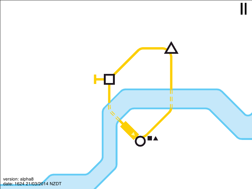
Mini Metro is a little game I found online. It’s currently a free flash game, but it’s been greenlit for Steam (which, for those who don’t know, is essentially an online game store that a lot of people – including myself – use). Basically, you start out with three stations. You can click and drag with the mouse to build a line between them. As soon as you do, commuters will begin to use your line.
The game is currently set in London, but there will be more maps (including New York and Paris), in the full release. The map does look a lot like London, with a geometric Thames running through the middle. You start out each game with three tunnels, used for crossing the river. If you decide to build a circle for the first three stations, you’ll probably end up having to use two of them.
 |
| A simple circle to start out the game. All of the line colors (you can have up to seven) for this map are based on real Tube lines. The colors will apparently change depending on what map you’re playing on. |
But soon more stations start to pop up. The three main ones are circles, triangles, and squares – the circles appear the most, the squares appear the least – and commuters are represented by these shapes, telling you where they want to go. They’re not picky, so they’ll go to any station so long as it’s the shape they want to go to. As your system grows (the game subtlely zooms out as you go along), new types of stations come up that only appear once – these can be annoying, as it can crowd the line servicing the one station.
You can connect to new stations either by extending lines (by clicking and dragging from their termini), or by building new ones. You start out each game with three railcars (each one holds four commuters), one of which is used for the first line. You can either use railcars to build new lines to connect to more stations, or you can use them to add more trains to existing lines (by default, new lines only have one train). This adds a bit of strategy – new line, or upgrade existing line?
Once you’ve transported 25 passengers safely, which doesn’t take too long, a “Budget Increase” menu comes up. You can choose between three upgrades for your system: an extra railcar, another tunnel, or a station upgrade, which can be dragged onto a station for extra capacity (more on that later). I find railcars to be the most useful, and end up choosing them every time, but that’s just my strategy. Budget increases happen when you reach certain amounts of passengers.
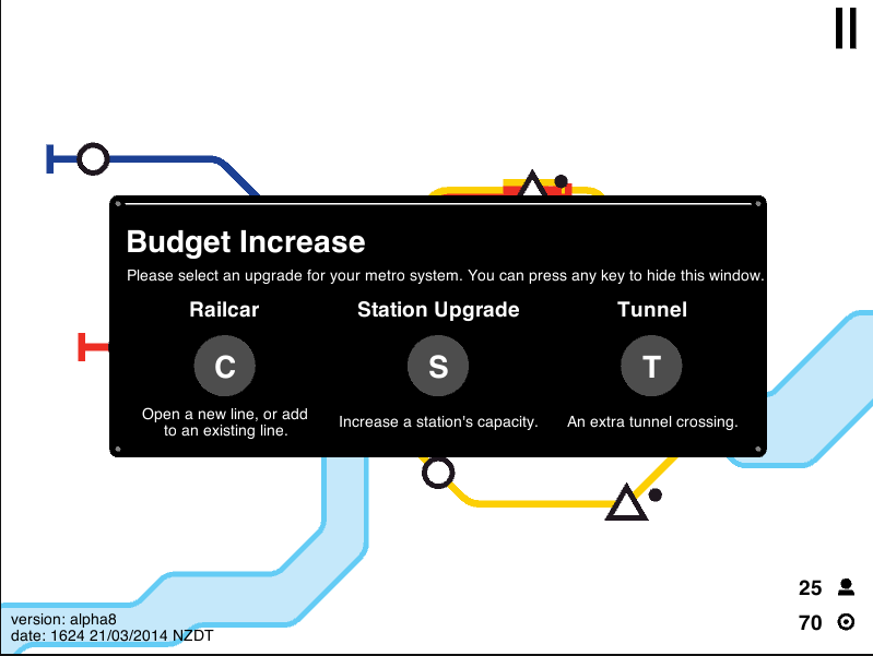 |
| You can also hide the menu if you need to. |
So this sounds like a nice, casual game, right? Wrong. Because if a station has more than six people waiting at it, a circle appears around it that starts ticking down. If it gets to nothing, it’s game over, and the number of passengers you transported is your score. Not so easy now, is it? And actually, the game is really hard! My record is 798, but I’ve seen people online with 1500 or 1600.
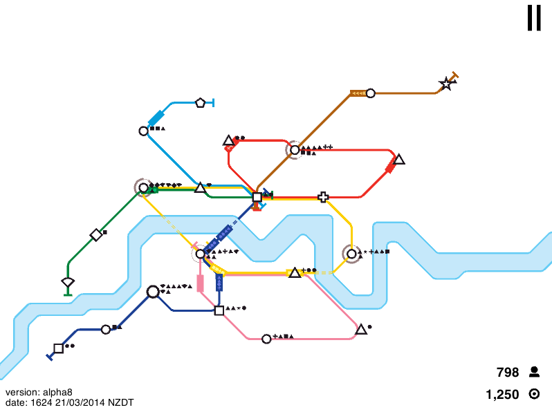 |
| This is my record. You can see that the system’s full of overcrowded stations. The third station on the Blue Line (Piccadilly in London), incidentally, is an upgraded station. |
All of the examples with over a thousand are entirely circle lines. And I know that circles are more efficient, but I feel like in real life the system wouldn’t be all circles. So I personally like to have realism over circles, but circles will get you a higher score (you can see in the above photo that I have three). Another good tip that relies more on luck is to make sure your stations are diverse. For example, let’s say you have a line branching off from another that’s all circles. This means that the line will only pick up people at the stops, then drop them off at the interchange. This will make the interchange overcrowded, and possibly lose you the game, although it’s not like you can choose what kind of stations come up.
And finally, I like to use my last line as a sort of a shuttle bus. If a station is overcrowded, I just draw a line between it and where the people want to go, then get rid of it once they’re dropped off. It’s sort of straddling the line between fair and cheating, but I do it anyway.
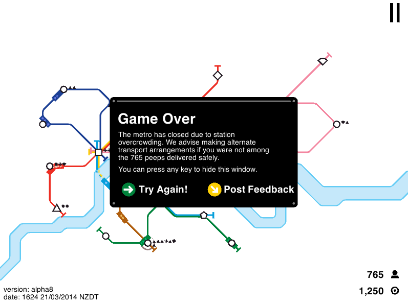 |
| So close to beating my record! I just wanted to show you the game over screen, as I had hidden it in the last picture. |
Game Link
Pros: This is an amazingly addictive little game that can also be really devious. I absolutely love it!
Cons: My only real issue is that although the little (computer) mouse showing you how to add railcars to lines is nice at first, it can get annoying when you see it for the 3,000th time. Also, when the game gets released on Steam you’ll have to pay for it, but I don’t really care about that.
Final Verdict: 9/10
65 (Brighton Center – Kenmore Station via Washington Street, Brookline Village, and Brookline Ave)
There are, for all intents and purposes, two buses that terminate at Brighton Center (I’m counting the 501/503 as one, since they follow each other for almost the whole route). When I ended up on the 501, I wanted to do the double-whammy. And lo and behold, there was a 65 right there when I got off! “When is this bus leaving?” I asked the driver who was taking a smoke. “About 5 minutes,” said the driver. “You can get on if you like.”
 |
| The 65 on Chestnut Hill Ave. I took this bus a while ago, as you can tell by the snow. |
One other person got on before we left down Chestnut Hill Ave. Right away, we turned onto Washington Street, heading through the main drag of Brighton Center. At St. Elizabeth’s Hospital, Washington Street made a sharp turn to the right. On the right side of the road there were mostly houses, and on the left there was a big park, then a church and some apartments.
We crossed Commonwealth Ave, with a connection to the B Line. There were some apartments and businesses, but it went back to houses soon after. At Beacon Street, though, Washington was lined with stores and taller apartments. But once again, it went back to houses. There was an interesting stop called “Gardner Path,” which looked like a long staircase, and then it started getting more urban.
We entered Brookline Village, where lots of small businesses lined the road. There was a very short stretch on Route 9, which Washington Street becomes, then we headed up Brookline Ave. Interestingly, whereas the 60 route (which joins up with the 65 at Brookline Village) makes a short detour onto Pearl Street to better serve Brookline Village Station going outbound, the 65 does no such thing. I’m not sure if there are any traffic rules preventing the bus from doing this, but I feel like it would be a no-brainer, really.
We turned onto Brookline Ave and went through a section of the Emerald Necklace, then through the tall buildings and hospitals of the Longwood Medical Area. They got slightly less tall when we crossed over another park and came very close to Fenway Station, but it was still very urban. The businesses lining the street ranged from chic to, well, not so chic. Fenway Park was visible to the right, then we crossed over Route 9. We turned onto Commonwealth Ave after, and pulled into the Kenmore Station busway.
 |
| The bus at Kenmore Station. |
Route: 65 (Brighton Center – Kenmore Station via Washington Street, Brookline Village, and Brookline Ave)
Ridership: It was pretty quiet for most of the route, but there was a massive spike in ridership at the Longwood Medical Area. There had been about 10 people on the bus until then, but the total ridership ended up being about 30. But I think the people who got on at the LMA were mostly just using it on a “whatever comes first” basis, as most of the buses on Brookline Ave go to Kenmore anyway.
Pros: It’s not a bad crosstown route between the branches of the Green Line. This is also the only bus on Washington Street, too. The weekday schedule is pretty good, running every 15 minutes rush hour and every 25-35 minutes during the day.
Cons: The last bus is at 8:30 PM, though, which is a very early cutoff. The Saturday service is only once an hour, too, with service ending at 5:30 PM, which is very early. Sunday service is nonexistent. I also find it weird that it doesn’t go onto Pearl Street in Brookline Village to better serve the Green Line.
Nearby and Noteworthy: As usual, I don’t have anything specific, but I love Brighton Center, and the bus passed through a lot of nice neighborhoods.
Final Verdict: 6/10
It’s a good crosstown bus, and it serves a lot in between the branches of the Green Line. But the schedule is pretty horrible on nights and weekends. The ridership wasn’t that great, I suppose, as most of the riders were on a “whatever comes first” basis, but no Sunday service seems pretty harsh. And I don’t see why the bus can’t go onto Pearl Street with the 60. That just makes no sense.
Latest MBTA News: Service Updates
Be sure to check out the poll on the right side of the page!
Polls Are Back!
I’ve decided to bring back polls! The reason I got rid of them before was because they were insanely glitchy, bouncing back people’s votes for no reason. It remains to be seen if that will happen again. If this doesn’t work, feel free to suggest a better poll gadget for Blogger – I’m using the default one for this poll. For now, though, attempt to cast your vote on the right of the page.