Random Photos: Unique London Tube Tracks
 |
| This is on the Bakerloo Line. |
Random Photos: Another Amazing Ad
 |
| Again, amazing. |
Random Photos: The Best Ad Ever
I’m not sure what Yoda has to do with free WiFi in Tube stations, but this is an amazing ad I found in London. Take that, Courtesy Critters!
 |
| Simply brilliant. |
Service Change: London, Part 2 – Other Tube Lines (Including the First Subway in the World!)
The Piccadilly Line (see last Service Change) was the only tube line in London that I took to the end. This post is a showcase on the other tube lines that I took for a few stops.
 |
| As usual, you can click on the map to make it larger. |
Hammersmith and City Line: The Hammersmith and City Line is one of the most useless lines, in my opinion. Starting at Hammersmith, it follows the Circle Line up to Liverpool Street. Shortly before the next stop, Aldgate, it breaks off and then follows the District Line to Barking. There are no solo portions on the H&C except for the short portion between Liverpool Street and Aldgate East. I only took the line two stops, anyway (from Kings Cross St. Pancreas to Barbican), but it was still an experience because I got to ride on the “S” Stock.
The “S” Stock is the newest train type in London, and its purpose is to give a unified fleet for all of the “subsurface lines.” The H&C, as well as the Circle, District, and Metropolitan Lines are classified as subsurface, meaning their tunnels are wider and shallower than tube lines (whose tunnels are bored into the ground and very narrow). This means that the trains are mercifully wider than on standard tube lines.
Anyway, “S” Stock trains feature air conditioning, better accessibility, and improved customer information. Interestingly, you can also walk through the whole train, and on the inside, it’s practically just one long car. That’s pretty much it for the Hammersmith and City. I didn’t really take it for a long enough distance to judge it properly, so all I can say to the H&C is: sorry.
 |
| A Hammersmith and City Line Train at Edgware Road using the older “C” Stock. |
 |
| The “S” Stock train leaving Barbican. |
 |
| The interior of an “S” Stock train, looking towards the back. |
Central Line: The Central Line is the longest line in London, the longest journey being from Epping to West Ruislip. There are also branches to Hainault (via two different routes) and Ealing Broadway, the branch I was on. If you remember from the last post, I mentioned going to Acton to see the London Transport Museum Depot. Well, since my mother is an avid walker, she wanted to explore Acton. We ended up walking to the center of town, where there were bustling fruit markets and a large fair event. We ended up deciding to walk to a completely different Tube station, as there are a fair amount in Acton. We walked through a lovely suburban part of town before reaching West Acton station on the Central Line (which got terrible signage).
 |
| West Acton Station. |
 |
| Kind of a useless map, isn’t it? |
The Central Line uses nice, modern trains on its route. Seeing as the Central Line is a “tube” line, the trains are again quite narrow. It’s above ground until White City, when it sinks below the surface through Central London. We got off at Holborn, where pictures of artifacts at the nearby British Museum adorn the walls.


 |
| Three views of Central Line trains at West Acton. |
Bakerloo Line: I have no idea what the heck a Bakerloo is. The line serves Baker Street station, so I suppose that could be the origin of its name? Don’t ask me. The Bakerloo Line starts at Elephant and Castle in the south, cuts through Central London, and then parallels with the London Overground line to Harrow and Wealdstone. The line used to go all the way up to Watford Junction, but now the London Overground handles that service. The trains look similar to the Piccadilly on the outside and the inside. However, Bakerloo Line trains don’t have the cute little armrests on the Piccadilly. Instead, they just have weird red protrusions out of the seats which do not give any rest to your arms whatsoever. Kind of annoying, but the trains are nice (and cramped, of course) overall.
 |
| A train at Baker Street. |
 |
| A train at Piccadilly Circus. |
 |
| Interior of Bakerloo Line train. |
 |
| A huge gap at Piccadilly Circus station. |

 |
| Sherlock Holmes design at Baker Street. |
Northern Line: The Northern Line is one of the most complicated lines on the system: trains can run from Morden to Edgware, Mill Hill East, or High Barnet via Waterloo or Bank. The line also has the longest continuous tunnel on the system (East Finchley to Morden via Bank), the deepest station (Hampstead), and the station with the longest escalators (Angel). I only took the line three stops, unfortunately (sorry, Northern Line!), from Kings Cross St. Pancreas to Camden Town. Northern Line trains look very similar to Piccadilly Line trains, but the interior is a little different.
 |
| A Northern Line train. |
 |
| Interior of a Northern Line train. |
 |
| You can see how busted these doors are if you look closely. |
 |
| A nice before and after picture from http://metro.co.uk/2009/03/05/a-new-beginning-for-the-circle-line-518126/. |
 |
| Paddington Station. |
 |
| I love the font on this countdown clock! |
 |
| I love this picture! |
 |
| Quite a bit of…wiring here. |
 |
| The wide interior of a “C” Stock train. |
 |
| Baker Street station on the first subway. |
 |
| Great Portland Street station. |
 |
| Euston Square station is more modern. |
That’s it for the London Tube, but we’re not leaving London just yet. Next time: London buses!
Anagram MBTA Map
I’m a little tired, since I just came back from a week-long vacation, so I’m a little late with my post. To tide you over, here’s this amazing anagram MBTA map:
 |
| http://www.cascadilla.com/arlington/ |
Random Photos: No Horsing Around!
 |
| I think the scale of these horses is a bit off. |
Service Change: London, Part 1: Services Around Heathrow Airport
There are essentially three ways you can get from Heathrow Airport to London (without taking a cab): the public bus (which I don’t even think I’d want to do); the Piccadilly Line; and the Heathrow Express. The Heathrow Express is marketed as “the fastest way between central London and Heathrow.” The ride only takes 15 minutes, however, it costs 20 pounds (around 30 US dollars) just to go one way! There is also a Heathrow Connect, which runs on the same tracks but makes stops along the way. The Heathrow Connect/Express is the easiest way to get around the airport (although there really is no easy way). The problem with using it to get around the airport is that if you want to get from Terminal 4 to Terminal 5, for example, you have to take two trains with a transfer at Terminals 1 and 3.
 |
| The stations at the airport are pretty nice. |
 |
| A countdown clock at the airport. |
Annoyingly, before you can board a train, they have to perform a “short security check” for what seems like no apparent reason. Every time, however, there was a person who completely ignored the announcements and tried to barge right into the train, anyway. Luckily, the check only takes a couple minutes.

 |
| Two views of trains coming into stations. |
The trains are very nice on the inside. The seats are big and fluffy, and they face forward (something I like, as you know). There are also automatic announcements (not that they’re really necessary on such a short ride), as well as “Heathrow Express TV,” which is mostly just a bunch of ads.
 |
| Destination board. |
 |
| These seats look so comfy! |
 |
| Heathrow Express TV. |
 |
| These seats don’t look as comfy… |
 |
| The classic logo at the entrance. |
 |
| A Piccadilly line train. |
 |
| A countdown clock on the line. |
 |
| Very tight. |
 |
| I think it’s funny how you can put your feet on the seats. |
 |
| Acton Town Station. |
 |
| The Depot Building, |
 |
| The depot entrance. |
 |
| A sign on the outside. |
 |
| The fare gates. |
 |
| A wider fare gate. |
 |
| A ticket machine. |

 |
| Covent Garden can get VERY crowded on weekends. |
 |
| Leicester Square Station. |
 |
| Piccadilly Circus Station. |
 |
| Russell Square at platform level. |
 |
| An alternative to the elevator, I guess? |
 |
| The exterior of Russell Square. |
Miniatur Wunderland (I Took Way Too Many Pictures!)
Wow. I didn’t know what to expect as I walked into the old building in Hamburg with “Miniatur Wunderland” written on it. It turned out to be an absolutely amazing place. It’s the largest model rail system in the world, and it’s still being expanded. It has seven different “worlds,” as well as a day-night cycle! This post will mostly be pictures, much like my Bay State Model Railway Museum post.
 |
| I’d hate to be on that bus. |
 |
| A large fair of sorts. |
 |
| This is what’s powering the trains. |
 |
| A railway station. |
 |
| A ski lift. |
 |
| A subway station. |
 |
| A castle in the mountains. |
 |
| A nice town. |
 |
| Another view of the town. |
 |
| Another view. |
 |
| Another station. |
 |
| There was clever flag placement in the models. |
 |
| A station at night. |
 |
| A station and a village. |
 |
| These mountains are HUGE! |
 |
| My favorite picture of the bunch. |
 |
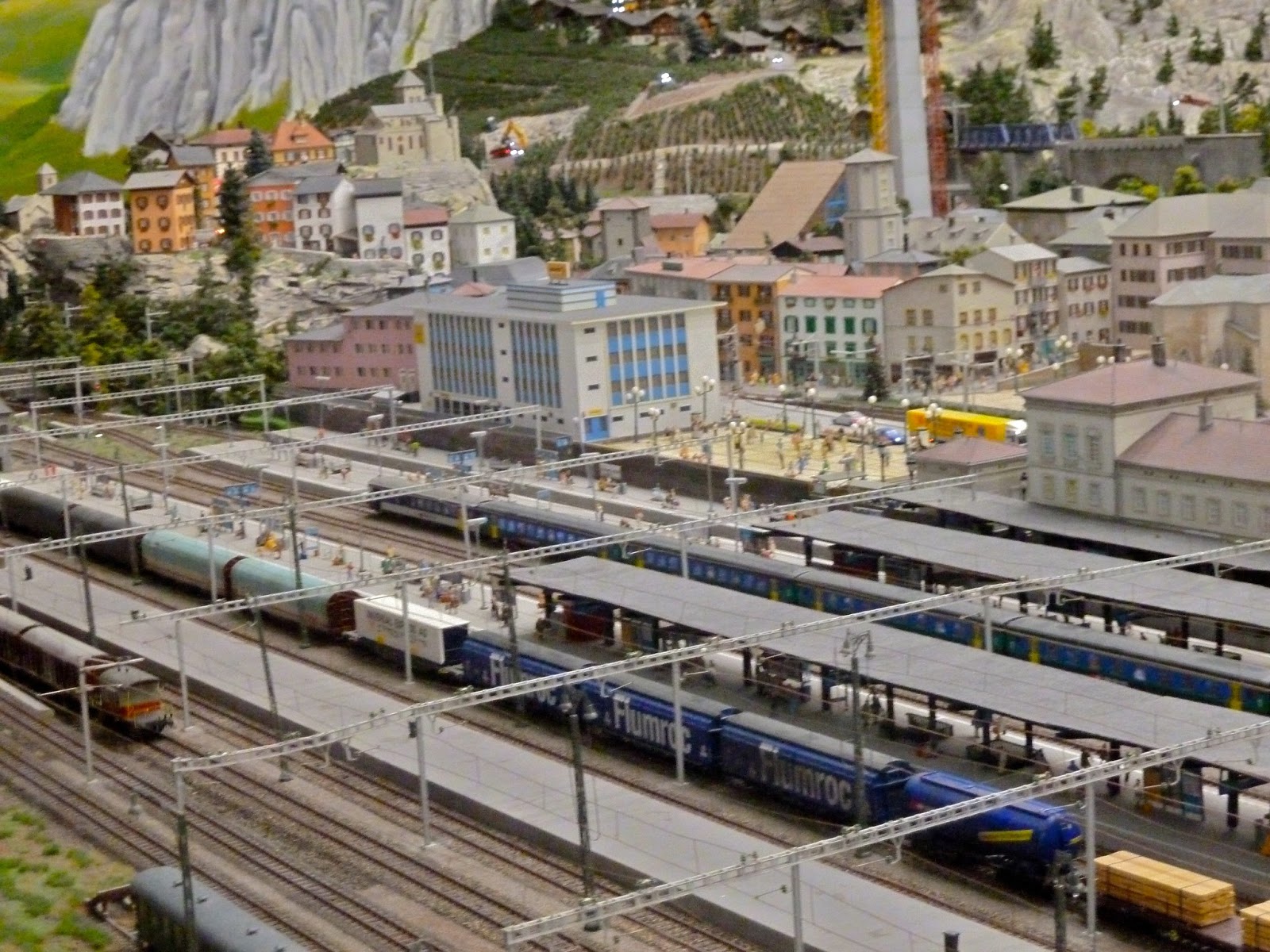
| High view of a Swiss village. |
 |
| More massive mountains. |
 |
| Another train. |
Bavaria: Bavaria is a much smaller world. Its main attraction is Neuschwanstein Castle, which is made of almost 4,000 individual parts.
 |
| This lets you see the scale of the models. |
 |
| Another view of the bridge. |
 |
| Neuschwanstein Castle, as well as a big blimp. |
 |
| A large crowd to see a tractor-pulling competition. |
 |
| A lovely view of a train going by a house. |
Knuffingen Airport: This is the newest as well as the most impressive world. Planes actually land and taxi around in this airport. There are also terminals, a parking lot, and a hotel.
 |
| Yes, there is an arrivals-departures board. |
 |
| Some planes with Bavaria in the background. |
 |
| Airport view from Bavaria. |
 |
| Some large planes pulling into their gates. |
 |
| A plane and its hangar. |
 |
| A parking lot. |
 |
| Some smaller planes. |
 |
| Looks familiar! |
 |
| A close-up of a terminal. |
 |
| Some planes at night. |
Austria: Another small one. This one has a small mountain with skiers.
 |
| A funicular climbing up the mountain. |
 |
| A cute little port. |
 |
| Ice skating! |
 |
| The aforementioned skiers. |
 |
| The aforementioned mountain. |
 |
| A mountainside with villages |
 |
| Is that a church behind the station? I think that’s a church. |
 |
| PRODUCT PLACEMENT!!! |
 |
| A lovely ski lift ride. |
Knuffingen: A quaint little town/city. I suppose this is the place that has Knuffingen Airport in it in real life.
 |
| They have a great sense of humor at Miniatur Wunderland. |
 |
| Knuffingen at night. |
 |
| Knuffingen in the daytime. |
 |
| An industrial area of Knuffingen. |
 |
| Oops! |
 |
| This lets you see the model scale well. |
 |
| This is the completely fictional Knuffingen Central Station. |
 |
| A train at Knuffingen Central Station. |
 |
| As you can see, the cars and trucks actually move. |
 |
| Yet another view of Knuffingen. |
 |
| And another. |
Middle Germany: My favorite part of Middle Germany is the funfair, which has 30,000 lights.
 |
| The funfair. |
 |
| A large parade. |
 |
| The funfair ferris wheel. |
 |
| The funfair at night. |
 |
| Some hills upon entering Middle Germany. |
 |
| The banner says “Miniatur Wunderland.” |
 |
| A rather grim scene of a corpse in the water. |
 |
| A streetcar going through a nice village. |
 |
| A much smaller fair. |
America: The America world includes parts of Florida, the Grand Canyon, Yosemite National Park, Mount Rushmore (neither of which I even saw), and Las Vegas.
 |
| This is Key West according to the map we got. |
 |
| As far as I know, there is definitely no train service to Key West. |
 |
| Miami’s main drag. |
 |
| Some trees in Florida. |
 |
| The classic sign! |
 |
| I took this monorail once in real life, and it wasn’t very useful. |
 |
| A Las Vegas train station. |
 |
| The suburbs of Las Vegas. |
 |
| Las Vegas downtown. There are many recognizable hotels and landmarks here. |
 |
| Look familiar? |
 |
| A small desert town. |
 |
| Some cacti. |
 |
| PRODUCT PLACEMENT ON THE FAR LEFT! |
 |
| There was an actual movie playing here.
(PRODUCT PLACEMENT ON THE LEFT!) |
 |
| These planes should be careful flying this low. |
 |
| See? |
 |
| A small desert town. |
 |
| Christmas! |
 |
| A fictional tunnel between Hamburg and America. |
Hamburg: There are many landmarks in Hamburg that are featured in the model.
 |
| A harbor. |
 |
| One of those contests where you bet on a square and if the cow you-know-whats on your square, you win. |
 |
| Uh-oh! |
 |
| Some beautiful canals and buildings. |
 |
| Hamburg Hauptbahnhof. |
 |
| Another major station. |
 |
| A harbor in Hamburg. |
 |
| The Imtech Arena was very cool. |
 |
| These cars on the Kohlbrand Bridge are going to run the camera over! |
 |
| A large tower. |
 |
| A harbor and part of Hamburg. |
 |
| A major train station. |
 |
| Hauptbahnhof again. |
 |
| A streetcar. |
 |
| Hamburg skyline. |
 |
| The Kohlbrand Bridge. |
Scandinavia: I actually didn’t take pictures of part of Scandinavia because my camera battery ran out. I got a lot of it, though.


 |
| Three views of the same cruise ship. |
 |
| A trippy garden. |
 |
| A trippy watering can. |
 |
| A nice little station. |
 |
| There was actually real water in this harbor. |
 |
| Surf’s up! |
 |
| A small village. |
 |
| An island in the middle of the real water. |
 |
| A monorail. |
 |
| A large station. |
 |
| The Storebaelt is the longest bridge in Miniatur Wunderland. |
 |
| The Storebaelt in the daytime. |
 |
| A cute little balloon. |
Hamburg’s History: There is also a very interesting set of models about Hamburg’s history. I didn’t take too many pictures, but here are the few I did take:
 |
| A tiny train station. |
 |
| Really tiny version of the Hamburg subway map. |
 |
| A view of modern Hamburg. |
Control Console: Visitors can see the control console of the Miniatur Wunderland.
 |
| Beautiful. |

 |
| Two views of the train’s-eye view cameras in the control console. |
So that’s my trip to Miniatur Wunderland! There is also a restaurant and a gift shop here, and they are still expanding the trains. Next up is Italy, which is under construction. Finally, here are links to their website and their Facebook page. I’ll be posting about my experiences in London next, so see you then!
Service Change: Hamburg – The S1 From the Airport and the U4 to Überseequartier
Hamburg’s subway, like many other German systems, is primarily split up into two parts: the U-Bahn and the S-Bahn. U-Bahn essentially means “underground,” although it still goes above at points away from the city center. S-Bahn has a few different meanings, but the most common is “fast train between cities.” Again, that is not always the case. In Hamburg, the U1 goes farther up north than the S1, for example. Also, like many other German systems, the Hamburg subway revolves around the Hauptbahnhof (central station). All lines stop here, as well as regional trains. There is also a large mall of restaurants within the complex.
(Note, by the way, that this post as well as the subsequent Service Changes will have a lot of pictures, so there’s a jump break)
 |
| This is simply a cropped version of a terrible picture I took of the Hamburg subway map. It doesn’t look good, but I couldn’t find any maps on the internet with the U4. |
I’m personally not a big fan of the Hamburg system map. It’s a little too angular for my taste, and it looks sort of ugly. However, I am a big fan of the system itself, because it’s so efficient. In Hamburg, door open buttons (used at Bowdoin on the MBTA) are used at every station. Tickets are not collected at all, although there are apparently random checks on occasion. It didn’t matter to us, since the hotel gave us free “Hamburg Cards,” which give you free access to public transit, as well as discounts at tourist attractions. But the best part of the system is the escalators: THEY DON’T MOVE UNLESS SOMEONE IS STANDING ON THEM! I absolutely love that! It’s so efficient!
Anyway, the ride from the airport is almost all above ground. The S1 has a short subway leaving the airport, and then it goes up at Olsdorf. It’s above ground for the rest of the ride, except for a small tunnel at Hauptbahnhof. The S1 trains are very nice both inside and out. They have the door open buttons, as I mentioned before, and on the inside of the trains the seats face forward rather than sideways. The seats face each other in groups, so there are backwards seats as well (uh-oh). The automatic announcements are mostly in German, although they are occasionally translated into English. It seems this only occurs at the important stations, however, such as the Hauptbahnhof or a terminus.
 |
| The S1 has maps on the ceiling. |
 |
| A bit blurry, I guess. |
 |
| There are also small trash areas between seats. I didn’t put that there. |
 |
| The S1 at Hauptbahnhof. |
 |
| The S1 at the airport. |
Admittedly, this sort of layout is probably less efficient than just lining up the seats along the train like we do on, say, the Red Line. However, I much prefer forward seats nonetheless, because they allow me to see out the window without craning my neck.
The S-Bahn’s above ground portion is mostly in an enclosed right-of-way…with LOTS of graffiti. It pretty much covers the entirety of the fences along the tracks. Other than the graffiti, in fact, there isn’t too much to see. You can interpret that however you want.
 |
| Get used to seeing this a lot. |
 |
| It’s a bit blurry, but you can easily see the graffiti plastered right on the front of that train. |
On the way to our hotel, we decided to make the transfer to the U4 at the Hauptbahnhof; big mistake. It was about a 10 minute walk to the U4 station, with microscopic signage. I don’t know if we did something wrong, but the trip took forever. When we were going back to the airport, we made the transfer at Jungfernstieg, which was much easier.
 |
| The huge Hauptbahnhof station. |
 |
| A regional rail train. |
The U4 is Hamburg’s newest line. It was opened in 2012 to Überseequartier in Hafen City, a massive docklands development. The U4 trains also utilize the door open buttons, and the interiors are pretty much the same as the S1 except for some strange color decisions. However, there are some interesting screens inside the trains that tell you the next station, as well as news. There are also maps on the ceiling, for some reason. The announcements are in both German and English on the U4. Also of note is the fact that if you stand up front, you can see the driver’s position as well as the tunnel beyond quite clearly. Unfortunately, the U4 only uses 4 car trains (the ridership probably isn’t that great yet), so your part of the platform might not get served.
 |
| Hauptbahnhof Nord, where the U4 goes. |
 |
| The U4 at Hauptbahnhof Nord |
 |
| This map must be very useful for people lying down. |
 |
| The oddly-colored interior of the U4. |
 |
| Überseequartier is so beautiful! |
 |
| Looking up into nowhere from Uberseequartier. |
 |
| A Hamburg bus. |
 |
| Why couldn’t OUR buses have countdown clocks? |
GUEST POST: Service Change: Go Bus to NYC
To tide you readers over while I continue uploading pictures, here’s a guest post! A blog reader from the start, Michele Markarian recently took the Go Bus to the Big Apple. She sent me her thoughts on the ride:
“Recently I had a meeting in New York City, and what better way to get there than the Go Bus? Apart from the fact that it departs from Alewife Station in Cambridge, a brisk eight-minute or so walk from my house, it was $35 round-trip and boasted free WiFi.
I left for the station on a Sunday morning. The ticket advised me to get there 15 minutes before departure. As usual, I was late, arriving for a 9:00 departure at 8:53. This turned out to be okay, as there was no sign of the Go Bus. One of the members of a friendly group standing near me said loudly that the Go Bus was not known for its on-time departure. Finally, the bus pulled up, and at around 9:03, we took off.
I had a nice, comfortable, blue sort of plush seat (not really plush, but it was nicer than a regular bus seat) to myself. There were probably 23 of us on the bus, and I was looking forward to settling in and getting some work done on the free WiFi once the bus was in motion. First, though, we had to stop in Newton at Riverside Station, where panic, seventeen more people were waiting to get on. Please don’t sit next to me, please don’t sit next to me, I kept saying in my head, even though I could not bring myself to stick a backpack or jacket on the seat next to me, as some people were. Miracle of miracles, the seventeen people got on the bus, nobody sat next to me, and we were on our way.
Other than the free WiFi not working at all, it was a thoroughly enjoyable ride. The other passengers mostly slept, and other than one stop at a highway fast food chain, the pace was steady. We actually pulled into Penn Station a half-hour earlier than expected, which gave me time to check into my hotel before heading off to the theater.
To take the Go Bus back, you have to wait outside on West 31st between 7th and 8th, and can I just say, the line was daunting. Once again, I was late, and as I stood in the cold with mostly students, all I could think about was getting my own seat. 35 people on the bus later, I did. Again, the ride was nearly flawless, except for a 12-minute-late departure, the free WiFi not working and the bombastic viejo sitting across from me, who decided to have a cellphone conversation at the top of his lungs. In the middle of his monologue about how he practically invented the Internet, he was tapped politely on the shoulder by a well-dressed gentleman from the front of the bus, who told him he was too loud. I was impressed with the gentleman’s candor, as all I could do was roll my eyes and write nasty things in my journal. This worked for about five minutes, and then the viejo started up again. I think the person on the other end of the line must have wearied of the drone, for the conversation ended shortly afterwards. Other than a stop to two fast food restaurants under one roof, we were home on schedule.
Pros: The convenience, comfort, and price! I would do it again.
Cons: In the past, they used to give out free bottled water, but neither leg of the journey featured this. Also, the free WiFi never worked. But I suppose a few hours without internet and e-mail is a good thing, especially with a window to look out of, right?”
Thanks, Michele!
 |
| The Go Bus at Alewife. From: http://www.yelp.com/biz_photos/go-buses-cambridge?select=8R1VcMTaH6RSceDn3Isq3A#8R1VcMTaH6RSceDn3Isq3A |
We Apologize For The Delay
I know I said I would get back from London and Germany on Tuesday. The flight was due to get back to Boston around noon, so I figured I could finish uploading pictures that day and start posting the next. However, I didn’t account for:
- The fact that I had much more pictures than anticipated, and
- My flight getting CANCELLED and having to get on another one on a different airline and getting the only seat pair in the whole plane with broken television screens and being forced to spend a 7 hour flight sleeping and reading only a decent book and getting out of Logan at 6 PM.
To make a long story short, I’m not ready to post yet. I’m still uploading pictures in bulk, and I should be ready by tomorrow or Saturday. Until then, happy 4th of July!
Quincy Center
I’ve passed through Quincy Center plenty of times, but I’ve never truly visited the station. I finally got the chance to when I was on my way to – you guessed it – ride a bus. I was actually blown away by the station layout and design.
The Red Line platform is quite nice. Although Quincy Center is pretty much an above ground station, it feels like a subway. Sure, you can see outside on both ends, but the platform itself is in a tunnel. It’s also very…shiny here, thanks to reflective pillars. I’m sure it can be cold here in the winter, but at least there’s shelter from rain and snow.
 |
| I love this platform. |
I wasn’t able to visit the Commuter Rail platform, but it looks like it has the same subway-like feel of the Red Line platform. According to Wikipedia, the Commuter Rail has a single platform and a single track. It’s served by the three Old Colony Lines: the Plymouth/Kingston Line, the Middleborough/Lakeville Line, and the Greenbush Line. The CapeFlyer also runs through it, but doesn’t stop.
The busway is quite good, though. There aren’t any massive mazes here, just a nice straight line. There are also plenty of bus options here. The 15 buses from this station all serve points around the South Shore. Unfortunately, none of them have very good service. There are only two buses here that run under every hour on Sundays, and they still only go every 40 minutes. That’s pretty bad service, although Quincy is pretty far south to be fair.
 |
| The busway is crowded, especially for a Sunday. |
Quincy Center has an impressive parking garage. It’s the oldest in the system, and it has over 850 spaces. Or at least it used to. The garage was closed “indefinitely” in 2012, as it’s apparently structurally unsound. People now have to park at other stations, which can be a large inconvenience. It’s really too bad, as it seemed like a large efficient lot from what I saw.
These are all connected by a standard mezzanine area. It has schedules of all the buses at the station and some fare gates. There are pretty urban surroundings around the station. Overall, I think this is a great station, although the closed parking lot just ruins it all.
 |
| Ugh. An old train. |
Station: Quincy Center
Ridership: This is a good station for commuters. Or at least it used to be. It’s not great now that the parking lot’s closed, though. People still change over from the train to the bus to get to places not served by the train.
Pros: I love the subway-like feel of the platform. It also feels pretty modern, even though it’s 40 years old. I absolutely love the busway, since it’s just a straight line. It’s also quite a large bus hub. 15 bus routes is a lot…
Cons: …but they all have pretty bad service. The stairs coming down to the platform are also in a pretty sorry state. When the speaker comes on to say a train is arriving, I just want to cover my ears because it sounds so bad. And the parking lot is closed. That’s just a massive inconvenience for commuters coming in by car.
Nearby and Noteworthy: There’s plenty to do around Quincy Center, and although I don’t have anything specific, I know that there’s a lot within walking distance here.
Final Verdict: 5/10
I fell in love with this station initially. I loved the subway feel of the platforms, I loved the busway, and I loved how large of a hub it is. But then, its cons became more apparent. The buses all have terrible service, the stairs coming down to the platform are in awful condition, and the speakers are torturous to listen to. The parking lot being closed was the final nail in the coffin; it’s just such a large inconvenience for commuters. I’m sorry, Quincy Center, but you’re not that great after all.
Latest MBTA News: There are shuttle buses on the Red Line running from Broadway to JFK/UMASS on June 29-30. Other than that, I’m departing for London and Germany today! I’ll be back next Tuesday.
Random Photos: Miles on the Green Line
On a school trip to a Boston Pops Concert at Symphony Hall, we ended up on a very crowded Green Line train (thus proving that the Green Line needs three or four car trains). I couldn’t grab onto a poll without inevitably dropping my umbrella (it was pouring out), so I fell a lot. My teacher ended up snapping this picture of me during the chaos, and it looks really good, I have to say. I decided to post it here.
 |
| Don’t I look spiffy…and nerdy? |
Random Photos: Elephant Sneeze
I encountered another bus advertisement with crudely Photoshopped animals. This one featured some elephants that were somehow able to fit onto an MBTA bus. I enjoyed this “Courtesy Critters” ad more than the previous hog-themed one, although I’m not sure why. I don’t think, however, that a person would actually stick their head into the back door of a bus just to sneeze in someone’s face…a bit unrealistic in that sense.
 |
| A bit crooked, as the bus was quite crowded and it was hard to get a picture. |
47 (Central Square, Cambridge – Broadway Station via BU Medical Center, Dudley Station, and Longwood Medical Area)
I have to admit, I’ve given the 47 short shrift. I’ve taken it twice, and I’ve never reviewed it yet. Today, I was going to review the 70 or 71, but then I saw that my blog has 47 posts (including drafts). I figure that was a sign that I should finally give the 47 some recognition.
That’s not to say it’s not popular, as it was relatively crowded when we rode on a Sunday. Of course, everyone got off at Fenway, but it was crowded nonetheless. The bus starts out at the big bus shelter in Central Square, the one on Mass Ave. Immediately after leaving, it makes a sharp turn onto Pearl Street. What follows is a lot of twists and turns through the residential neighborhood of Cambridgeport. Due to one way streets, the route the bus takes is different depending on which way you’re going. The bus then crosses Memorial Drive and goes over the B.U. Bridge. It has a decent view, although there are much better views elsewhere on the system.
 |
| Don’t you hate it when bus drivers turn the destination board to “NOT IN SERVICE” and ruin your picture? |
The bus then crosses the B branch of the Green Line, although the B has no stop there. It then turns onto Mountfort Street, right next to I-90. Then it turns onto Park Drive and passes the C branch just before it goes above ground to Saint Mary Street Station. It then crosses over the D branch and serves Fenway Station. This is where many of the people on our bus got off. The bus then goes down Brookline Ave to serve the Longwood Medical Area. This is another big area in terms of ridership.
 |
| Five years later, here’s an actual picture of the 47 in Central Square… |
After serving the LMA, the bus makes its way to Museum of Fine Arts Station on the E branch of the Green Line. It then travels down Ruggles Street and serves Ruggles Station. Instead of following the other buses on Malcolm X Boulevard, the 47 goes on Ruggles Street (or Melnea Cass Boulevard in the other direction) to Dudley Station. The bus then serves the B.U. Medical Area, which has a small number of bus routes for MBTA standards. It then goes onto Albany Street, leaving the many buildings of the Medical Area for a more industrial neighborhood. It goes under I-93, and then turns onto West 4th Street, a bridge with a great view of the Red Line’s Cabot Yard, as well as the bus area of the yard. There are numerous buildings again as the bus pulls into the Broadway Station bus stop.
 |
| A terrible picture of Cabot Yard. That darn fence got in the way. |
Route: 47 (Central Square, Cambridge – Broadway Station via BU Medical Center, Dudley Station, and Longwood Medical Area)
Ridership: In our case, there were a lot of sports fans looking to see a baseball game at Fenway Park. In most other cases, people probably just use it to save time (see “pros” below). This is not a bus that people would take from beginning to end, though, as the train is a much faster link between Central Square and Broadway. There were about 40-50 people on our bus.
Pros: It’s a great crosstown bus. It can save a lot of time if you’re trying to go from Central Square to Fenway, for example. It’s also the only MBTA bus to serve Cambridgeport (besides the 64, but that’s only in one direction), and it cuts right through. People seem to use these portions, too, so it gets good ridership in Cambridgeport. It has a pretty good schedule, with headways of a good 22 minutes on weekdays and 24 minutes for most of Saturdays.
Cons: Every 40 minutes on Sundays isn’t very good, especially because of the ridership I saw, and because of the urban nature of the bus in general. Based on what I saw, the bus really doesn’t have to go to Broadway. Considering that there’s not much between the B.U. Medical Area and Broadway, and the fact that there was only one person who rode past the medical area, I think that buses can just terminate at the B.U. Medical Area. Perhaps the ridership is different on weekdays, but going all the way to Broadway seem unnecessary based on what I saw.
Nearby and Noteworthy: Aside from places in Central Square, which is for another post, the bus (as well as a few others) goes quite close to the Museum of Fine Arts. Most people probably know about it already, because it’s a great museum that recently had a large expansion. If you haven’t been, I strongly recommend you go.
Final Verdict: 7/10
I think the best thing about this bus is the fact that it’s a great time saver. It also connects with all of the MBTA lines except for the Blue Line. However, unlike the 1 or the 66, this bus does not run very frequently, at least not on Sundays. The rush hour headways are also bad compared to the 1 or 66, but every 22 minutes is pretty good for a non-Key Bus Route. I also don’t think it needs to go all the way to Broadway, but that’s just my opinion. Overall, it’s one of the great shortcuts on the system.
Latest MBTA News: The MBTA is launching a Key Bus Route Improvement Program to improve Key Bus Routes physically and in terms of service. The parking lot at Salem Station on the Commuter Rail is due to close for a massive renovation. There will be shuttle buses on the Blue Line from Suffolk Downs to Wonderland on June 23, 24, 25, 27, and 30 from 9 PM to the end of service. There will also be shuttle buses on the Red Line between JFK/UMASS and North Quincy this weekend. In addition, there will be another bus review on Tuesday because my mother and I are taking a trip to London and Germany! I’ll be back on the following Tuesday to talk about my public transit experiences, with numerous pictures.