John Collyer Asks…
Transit Tales: Pulling a 188
You may remember my hatred for the 188 bus in London because it drove right past my mother and I at the bus stop. Well, it happened again, this time right in Boston. I was taking my mother out to the MFA, and I managed to somehow convince her to take the bus home. I told her that the 47 would cut the journey by a lot and also save us from dealing with the E Line. Right when we exited the MFA, we saw a bus on Ruggles Street. Getting closer, we saw it was the 47. The bus had already past the Huntington Ave stop, and was speeding towards The Fenway. My mother tried to yell to the driver, “Where’s the next stop?” but he just pretended he didn’t notice. I broke away and ran after the bus up until the next light. I was standing right outside the doors, and still the driver pretended I wasn’t there. The light changed to green, and the 47 sped away. We had to go back to the bus stop, wait for a really long time, and ended up getting a CT2 “Limited Stops” express service to Kendall. Unfortunately, the bus barely skipped any stops whatsoever and got stuck in a massive traffic jam. Express bus, my foot.
Michele Keenan Asks (Again)…
 |
| A rusty trolley leaving Mattapan Station (in the winter, of course). |
 |
| Looking into Mattapan Yard. |
 |
| People getting on a train at Mattapan. |
Pictures of the Completed Wonderland Bridge
I took these pictures at the same time I took the 441/442, so I am extremely late. Nonetheless, the bridge from Wonderland Station to Revere Beach is complete, and here are some pictures of it.
 |
| Parts of the bridge are NOT finished… |

 |
| Two views of the bridge. |
 |
| This looks like one of those 3-D construction models to me. |
 |
| What a lovely view of the parking lot (my father would remark that those lights don’t have to be on during the day). |
 |
| And again! Beautiful! |
 |
| A marginally better view, but not that much better. |
Overall, a very nice link between Wonderland and Revere Beach. I doubt it will be used very much, since Revere Beach Station is the more obvious choice, plus a lot of the beach attractions (namely, bathrooms) are closer to Revere Beach.
71 (Watertown Square – Harvard Station via Mount Auburn Street)
I’ve taken the 71 twice so far, but haven’t gotten around to reviewing it yet. Since it got requested to me by Eric Cornell, however, I feel compelled to review it. The best part about the 71, of course, is that it’s a trackless trolley (and I love trackless trolleys). One of the two buses to really serve Watertown (there are others, but they only just nick Watertown Square), the 71 travels through a more suburban-residential part of Watertown, unlike the strip malls and industrial areas along the 70.
The 71 and 73 board on the lower busway at Harvard Station, requiring an interesting way of paying your fare. Since the lower busway platform is on the left side of the bus, you have to enter in the left-hand door in the center of the bus. You actually don’t pay your fare until leaving the bus, which requires sort of an honor system of paying. There are no instructions in the busway about this, so I was a little confused the first time I rode.
 |
| A very low-quality (and terrible in general) picture of the 71 at Harvard. |
Exiting the busway, the bus immediately turns onto Mount Auburn Street with a stop just outside the post office. Leaving Harvard Square, Mount Auburn Street gets suburban very quickly. The bus passes the Mount Auburn Hospital, a major stop, and then goes by the Mount Auburn Cemetery. Intersecting with Brattle Street, things get more urban again, with apartments and a small clinic. The bus also passes Aberdeen Ave, the terminus for the 72 bus, and shortly after the 71 and 73 split up, the 73 travelling up Belmont street and the 71 staying on Mount Auburn.
At this point, there’s a mixture of houses, churches, and businesses, including yet another medical center. The bus passes a large sporting complex among an almost purely residential portion with a few churches dotted in here and there. Nearing Watertown Square, reasonably large buildings start popping up, including a shopping center with some big-name stores. The bus then enters the small Watertown Square (not yard) busway, shared with the 59 bus, as well as the 70 on nearby Main Street. The wires continue off to Watertown Yard, although the yard isn’t running anymore (I’ve always thought it was kind of a sad place, but that’s just me). My father and I were one of the three or four people who got off in the busway, the other passengers getting off one stop earlier to get to the businesses of Watertown Square.
 |
| A MUCH better picture of the 71 at Watertown Square (shouldn’t that destination board say “Harvard?”). |
Route: 71 (Watertown Square – Harvard Station via Mount Auburn Street)
Ridership: I’ve ridden this bus twice towards Watertown, and both times there were only about 10-15 people on it. Both times, however, I would see buses going the other way that were packed…I have no idea. The bus seems to mostly consist of routine riders, since most people knew how the fare system works and the driver seemed to know everyone’s names.
Pros: It’s a trackless trolley – duh! Also, it’s one of the only buses to really serve Watertown, and it serves a lot of it. Being a Key Bus Route, it has a very good schedule, running every 9 minutes rush hour, every 15 minutes midday and Saturdays, and every 20 minutes Sundays – although, as someone I know described it, “There’s one 71 for every five 73’s.” Although the 73 runs a little more often than the 71, I don’t think I would exaggerate it that much, although I do see more 73’s than 71’s on Mount Auburn Street. Also, I have never, ever seen the 71 bunching, a feat rarely pulled by Key Bus Routes.
Cons: Not much, except for the fact that the fare system’s a bit weird. I wish there was some signage about it at Harvard, but that’s about it.
Nearby and Noteworthy: There’s a vegan restaurant on Mount Auburn Street called The Red Lentil that’s absolutely delicious. I’ve only ever been for breakfast, but it’s very good food. In Watertown Square, there’s also the Armenian Library and Museum of America, a museum that features Armenian artifacts from the past 3,000 years. It makes for a very interesting hour or two, and the third floor exhibit changes every few months.
Final Verdict (1-10): 9
I may be biased, since this is a trackless trolley, but it serves a large part of Watertown, has a good schedule, and doesn’t bunch (and it’s a trackless trolley). It’s never been crowded for me, but I often see 71’s that are quite full, making it a bit hard to judge the ridership (but it’s a trackless trolley). Overall, a very good, frequent bus (that’s a trackless trolley).
Latest MBTA News: Service Updates
Something the MBTA hasn’t displayed on its website for some reason, is the new rail line they announced just a few days ago: it’s a shuttle between the Convention Center in South Boston and Back Bay Station utilizing an abandoned track. It’s meant to create a direct transit route between the Convention Center and “downtown,” since there is currently none. While I think it’s a great idea, I do think the route is a bit crazy:
 |
| Image source |
It would be nice if they could just cut across so as to bypass the South Bay rail yard, but there’s no existing right-of-way there, so it would be very expensive to build. It should be ready in two years, hopefully. Many more pictures here.
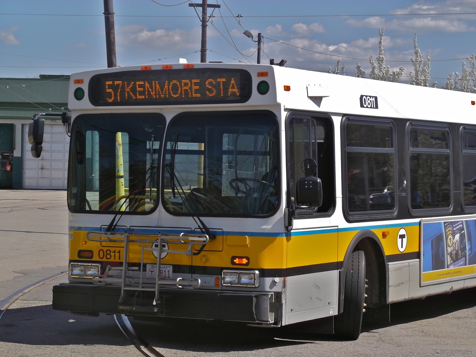
57 (Watertown Yard – Kenmore Station via Newton Corner and Brighton Center)
After what seems like forever, here’s a regular MBTA bus review! Unfortunately, my computer was acting up, so this is very late. Anyway, the 57 was requested to me by TheMBTADog, and since I had taken the bus already, I figured I’d review it. People often wonder why on the Green Line, there’s the B, C, D, and E branches, but no A. Well, there used to be an A Branch that went to Watertown Square, via Union and Oak Squares (it was mentioned in my 52 post). In 1969, the route was eliminated, but the tracks to Watertown remained because there was a yard in Watertown. It wasn’t until the 1990’s that the tracks were destroyed. There remains a stub of the former track at Packards Corner on Commonwealth Ave. Anyway, the 57 is the bus replacement for the A, and based on the crowding, it’s certainly worse than the former light rail.
The bus starts at Watertown Yard (not Square), where there were a fair amount of people waiting. The bus then follows the 52 (and the 502/504 express buses to Boston) down Galen Street. After making the loop around the Crowne Plaza, it makes its way to Tremont Street, which is a residential area, along with the 501/503 buses to Brighton Center from Boston. It then reaches Oak Square, the part-time terminus for the former A Line, as well as the terminus for the 57A short-turn from Kenmore. Oak Square has some assorted small businesses, as well as a large YMCA that I took swimming lessons at as a kid.
 |
| The 57 at Watertown Yard. Note the old A Line tracks the bus is crossing. |
It gets fairly urban after, with a small shopping center and three-to-four-story apartments. The bus then enters Brighton Center, a lovely area with small businesses with apartments on the upper floors. This is another important transfer point. The bus goes by the massive Saint Elizabeth Medical Center, and Washington Street becomes Cambridge Street. The bus passes a large park/forest area, and then it gets more suburban and residential. It isn’t long, though, before things get urban again in Union Square and the bus turns onto Brighton Ave. Union Square is mostly one-story small businesses, but there are a few taller buildings here and there. As the bus gets closer to Boston, some large chains start to pop up among the lesser-known places.
I haven’t said much about ridership this post, but let me just say that at this portion of the ride, the bus was so crowded that the driver wasn’t letting people in. Luckily (well, sort of), there was some bunching, so the bus right behind us was able to pick up the stragglers. Soon, it gets more residential with some apartments. However, businesses pop up again as the bus gets closer to Commonwealth Ave. Note as you’re riding (whether it’s the B Line or the 57) the small stub track of the former A Line here. For the rest of the ride, the 57 runs alongside the Green Line tracks to Kenmore. As one would expect, it’s quite urban along this stretch, including the many buildings of Boston University. Soon after, the bus enters the Kenmore Square busway with many people getting off. There was also a throng of people waiting to go back to Newton and Watertown.
 |
| “Feed me,” said the bus. |
Route: 57 (Watertown Yard – Kenmore Station via Newton Corner and Brighton Center)
Ridership: Lots and lots and lots of people. I counted over 80 in total. Many of then went to Kenmore, so I’m assuming there was a baseball game they were all attending, although I can’t be sure. Since it serves B.U., it probably gets its fair share of student riders, too.
Pros: Being a Key Bus Route, the bus has a great schedule, running about every 10 minutes, Monday through Sunday. During rush hour, the 57A also runs every 10 minutes to Oak Square, providing additional service. The bus serves a large, mostly urban part of Newton and is the sole service along most of its route (aside from the rush-hour only 501 and 503 express buses). Taken on its own, it’s a pretty good bus.
Cons: Unfortunately, when compared to the A Line, the bus is ultimately (and expectantly) worse, mostly because of its crowding. Articulated buses would be great on this route, especially considering that the 39, which replaces the former E Line to Forest Hills, uses articulated buses. The 57 also has the typical nuisances or Key Bus Routes, namely the aforementioned crowding and bunching.
Nearby and Noteworthy: Aside from B.U. and Kenmore Square (the latter will be talked about most likely in a later post), Watertown Square (on the northern side of the Charles) has a staircase that leads down to a dock/platform area right down on the river. It’s a really quaint, beautiful area, made more so by the fact that I went there at sunset.
Final Verdict: 7
This bus has a lot going for it; the schedule and the large area served are the two main pros. However, 80 people on a single bus ride? I don’t know if the bus is usually like this, but that is very overcrowded. As I said before, articulated buses would benefit this route greatly. There’s also the bunching, but that’s pretty much a given for a Key Bus Route.
Latest MBTA News: The Orange Line is running shuttle buses from Sullivan Square to Oak Grove at random dates…check the website to see if any affect you. The MBTA is stressing the fact that some bus stops are being eliminated or moved as part of the Key Bus Route Improvement Program. Click here for more information. You’ve probably found out about this already if you live in the area, because I’m very late on this, but Salem Depot is now closed. All Salem buses are being rerouted to a new busway.
Also, the MBTA has announced the winners of its map contest. You can vote on which one you want to win here. And the MBTA also has a new safety video that’s very…weird. Watch it below or here. Comment your opinions, I want to see what you guys think of this.
Service Change: Kendall/MIT – CambridgeSide Galleria Shuttle Service
Back in Boston! This is a free shuttle bus from Kendall/MIT Station to the CambridgeSide Galleria shopping mall. It makes no stops except for one on Binney Street, and it runs every 20 minutes, every day. The hours of service coincide with the opening and closing times for the mall, so Sunday service starts at 12 P.M. I hadn’t even heard of this until my friend told me about it. I had no intentions of taking it, but when my father had to go to the CambridgeSide, I looked at the directory map and saw that the shuttle was marked on the map. “Why not?” I thought.
Finding the shuttle proved to be quite hard, though. There was no signage outside, and no benches to suggest a bus stop. We had to ask someone working at a tour company to find out where the stop was. We got the location right, it turned out, but the only benches were in a park rather set back from the road. After what felt like a very long wait, a bus finally came. It wasn’t like an MBTA bus, more like a mini school bus of sorts.
 |
| Signage, anyone? |
A few people got off, but there was only one person who got on besides my father and I. The bus had big comfy seats, which is always a plus. But as the bus started moving, I noticed a small lever down below the seat. When I pulled it, I found out the absolute best thing about this bus: the seats reclined. I brought it way down and relaxed.
 |
| It actually kind of looks like a prison bus from here. |
 |
| Looking up front. |
The bus makes its way to Binney Street, which is pretty industrial. There was a point when the bus driver opened the doors for about a second, but nobody got on or off. This must’ve been the Binney Street stop. The bus eventually turns onto Broadway and enters Kendall Square proper, with its large buildings. It makes the same loop around the Marriott that MBTA buses do. At the Kendall Square busway, the bus opened its doors and we all got out (all three of us). Here at Kendall, the bus actually has a little signage, so presumably more people use it to get to the mall than come from it.
 |
| The bus at Kendall. |
I will be in Vermont (again) until Monday, and next time there should be a regular bus review (unless I take any buses at the “Trapp Family Lodge,” which is unlikely).
MBTA Control Center – Exclusive Report!
Wow, how late can I get? First of all, I really want to thank Dave and Bettina Gentile for letting me visit the MBTA Control Center in Boston. I heard the MBTA offers tours, but I know nothing about them. However, what goes on inside the building is top secret (no pictures allowed within the actual control rooms), so know that this is not a full disclosure.
Upon entering the building, there’s a lobby with three maps facing you: a subway map, a full system map, and a Commuter Rail map. They also have every bus schedule for the system, though I don’t know who would use them. On the right side of the room, there’s a big “T” with very realistic models of trains, a bus, a boat, and a THE RIDE vehicle (see pictures below).
However, though the lobby is interesting, the best part is in the actual control room. A huge screen lines the entire wall, showing every single line, station, switch, and train running on the system. People at computers can control signals and tell trains when to leave the station. They have security cameras to every station in the center of the screens. It’s really like “walking into a star ship,” as Bettina describes it.
To sum things up, they control everything in here. However, sometimes a switch will break, causing operations to have to be done manually, thereby slowing all the trains down. They also control the buses, though what exactly that means, we don’t know because we weren’t allowed inside the bus control room. Nonetheless, I conclude by thanking Dave and Bettina again. Without them, this never would’ve happened, and it’s truly an amazing experience. Now here are some photos:
 |
| Just to remind you where I went. |
 |
| It’s going to Riverside, it seems. |
 |
| It’s hard to tell in the light, but this is a model Blue Line train. |
 |
| Hmm… this bus doesn’t have a destination sign… |
 |
| No idea where this Commuter Rail train is going. |
 |
| This Orange Line train looks a little like a plush toy to me. |
 |
| So does this Red Line train. |
 |
| Probably my favorite model of the bunch. This one’s outside of the lobby in its own case. |
 |
| All the models together. |
However, I found out that the MBTA has a picture of the control center right on their website! Here it is:
I don’t see why they stress this whole “secret control center” thing when they have a picture for everyone to see on their website! You can also get very good pictures by searching “MBTA Control Center” on Google Images. Turns out it’s more public than expected…
Service Change: London and Germany – Conclusion
This post is simply a round-up of the forgotten pictures – the ones that weren’t included in posts. Enjoy!
 |
| The surreal view from Uberseequartier Station. |
 |
| Uberseequartier from the ferris wheel seen above. |
 |
| Bunching on the 29 bus! |
 |
| Unfortunately, half the time this screen showed soda advertisements. |

 |
| London bikes for hire! |
 |
| These are found in all stations. |

 |
| Everything looks good on the Underground! |


 |
| …or not. |
Service Change: Vermont – White River Junction and Burlington Bus 6
We’re back in New England, but not Boston just yet; we’re looking at White River Junction, a town with a railway history, and Burlington, the biggest city in Vermont.
 |
| Nice shelter. |
 |
| The map in the shelter. |
 |
| I have no idea why they have schedules for all the bus routes… |
WRJ also has a railroad “museum” and an old locomotive from the Boston and Maine Railroad. The locomotive is in a shelter right near the Amtrak Station. There are stairs leading up to a place where you can look at the controls for the locomotive. There are labels, as well as information about the locomotive.
 |
| The locomotive up front. |
 |
| The caboose. |
 |
| The inside. |
 |
| Information on the locomotive. |
The railway museum was mainly just a gift shop with a few old artifacts. It was kind of touristy, but interesting. The items on sale were mostly things like wooden train tracks, and there was a relatively creepy statue of a conductor. Through a hallway is another store with other merchandise not related to the railway.
 |
| Why did I never hear of this? |
 |
| Antique railroad crossing. |
 |
| Antique signal. |
 |
| That conductor is so creepy. |
The Amtrak station is barely anything. All it is is a low paved platform and a lot of freight cars. There’s a ticket office and a baggage area, although neither of them seemed open. Admittedly, a daily service doesn’t need much of a station, but it was still very disappointing.
 |
| I don’t think the sign is necessary. |
 |
| Hello? |
 |
| Is anyone in there? |
 |
| Man, this joint is hoppin’. |
Burlington: Burlington has a small bus network for itself, with 19 routes: most are local routes, but there are a few “LINK Expresses” that travel to far-flung towns and cities (including Montpelier). I wanted to take a bus there, but considering how stingy my mother is with buses, I decided at first to take the short 11 bus (College Street Shuttle), since it’s free. However, it turns out that the 6 (Shelburne Road) (I don’t know why “Normand” is in the PDF link) goes right by the hotel we were staying at, so we decided to use it to get to downtown Burlington.
The 6 follows a very straightforward route, spending most of the time on Shelburne Road. In Shelburne, it makes a short loop and serves the Shelburne Museum, then heads back up to Burlington. It serves the Vermont Teddy Bear Co. factory part-time, more aimed for workers than shoppers. Of course, we didn’t do all this. Our hotel was about halfway down the route (Harbor View Road on the map), with a nice shelter.
 |
| I love the design of the shelter! That wastebasket is overflowing, though. |
 |
| A convenient schedule inside the shelter, although it would be nice if it showed the arrival times for this particular stop (that goes for you too, MBTA). |
 |
| Stop! Bus! |
 |
| It’s hard to see, but there’s a solar panel up there for the light at night. |
 |
| Interesting view in the back of the shelter. |
 |
| Another rainy view of the shelter. |
 |
| Solar! |
 |
| Not the greatest bus stop design, in my opinion… |
The bus runs every half hour Mondays through Saturdays (not bad), but it doesn’t run on Sundays (on Sundays, most local routes are replaced by a large loop called the 18). Fares in Burlington are $1.25 for local routes – exact change only, which is always annoying, although passes can be bought. The inside of the bus had dark green seats and pull chords to request stops. In place of ads, there were posters talking about bus etiquette (without creepy animals, MBTA).
 |
| The 6 “TO BURLINGTON.” |
 |
| The interior of the bus looking frontward. |
 |
| The interior of the bus toward the back. |
 |
| Yeah, don’t hog a seat. |
 |
| The 6 from the side. |
 |
| This strangely reminds me of the picture of the 350 I took. Perhaps it’s because they were both going to Burlington. |
 |
| This is the only use of the screen up front. |
Important stops are announced by the driver, meaning the screen up front is only to say that a stop was requested. There were only five people on the bus when we got on, which at first made me think it had low ridership since we were halfway down the route already. However, as the bus went toward Burlington, more people fed into the bus and by the time we were downtown, all seat pairs were taken.
 |
| The seats are facing away from the road, for some reason. |
 |
| The 6 at Cherry Street. |
 |
| An example of the fleet of smaller buses at Cherry Street. |
 |
| A large wall of bus shelters at Cherry Street. I wonder what that “Free Magazine” is… |
 |
| The bulk of Cherry Street is just shelters. |
 |
| The large shelter. |
 |
| The cluttered ticket booth. |
 |
| Another area of Cherry Street with just shelters. |
 |
| Nice clock. |
 |
| Beautiful electronic information screen! |
 |
| A large system map on a brick wall. |
 |
| Some old wires from the line. |
 |
| A sign about it. |
Michele Keenan Asks…
“What is your favorite bus route in Boston and why?”
I think I have to say the 1. It’s one of the best shortcuts on the system, and although it suffers from overcrowding and it’s hard to find at Harvard, I still love it. People may note that the 31 got a 10 while the 1 only got a 9, but that’s simply because the 31 fits the unwritten criteria more than the 1 does. Although the 31 is a great bus, the 1 just feels more useful to me. However, maybe it’s because I don’t live in the Mattapan area. It’s hard to say, but I love the 1, anyway.
Service Change: London, Part 4 – Network Rail to Stevenage, the Nene Valley Railway, Railworld, and the Ferry Meadows Miniature Railway
We’ve got some transit oddities (as well as the UK’s Network Rail) in the final post in London. There may be a post after this one with all the pictures I meant to post but didn’t, but it likely won’t be very long. For now, however, let’s go back to London (or at least the UK) for the last time.
NOTE: “P” in photo captions mean the photo was taken by Paul, my mother’s friend. These pictures were on an iPhone, so they’re a little lower quality, but I’m grateful he took pictures because my camera ran out of battery halfway through the trip.
You’re probably wondering why I went to Stevenage, of all places. My mother has a friend up there (who also took some of the pictures in this post), and we went to go visit him and his wife. Network Rail operates a very extensive network all across the United Kingdom (as well as France), and very efficiently. If you’re going to Stevenage (considered a major station), for example, some trains stop at every single stop along the way. Others make one stop at Finsbury Park (with a connection to the London Underground), and then run direct, and still others make no stops on the way to Stevenage, heading out to terminate at a farther destination. I think this is a great way to run a commuter railway, but that’s not the best part. The trains run very, very often, running from every 10 minutes to every half hour, even on Sundays! Simply amazing.
The train to Stevenage leaves from Kings Cross, which is a nice 15 minute walk from Russell Square (where we were staying, if you remember). However, my mother and I decided to take the Piccadilly Line instead, which consisted of getting our tickets, braving large crowds in a tiny elevator, and walking onto the platform just as the train left. Nonetheless, we made it to Kings Cross Station on time. It was a very beautiful station, with the ticket area being very modern and the platforms being a little more old-fashioned (which is not a bad thing).
 |
| The LONG walkway from the Piccadilly Line to Kings Cross proper. |
 |
| The modern ticket hall. |
 |
| The platform area. |
The train we took terminated at Peterborough, which is a relatively far distance, so the only stop between Kings Cross and Stevenage was Finsbury Park.
 |
| The train from the front… |
 |
| …and the side |
The interiors of the trains have forward (and backward) facing seats (Hooray!), some in groups of four and some in two. You can walk between cars, something I didn’t have to do on my journey. The trains have door-open buttons (something I love), and every time the train arrives at a station, there’s a “ding” noise, and the buttons light up for the passenger to push. The trains also have automatic announcements saying the current stop name, as well as the list of stops the train makes.
 |
| Forward facing seats! Yes! |
 |
| The doors between cars. |
The ride was very nice; it turns very rural soon after leaving London, so the train travels through the country with some nice views along the way.
 |
| Stevenage station. |
Stevenage station was pretty standard fare, with covered platforms connected by a lobby area, but interestingly enough, the station uses the same fare gates as the London Underground! We were a little confused, so we just gave our tickets to a real human, who gave them back and said we needed them for the return trip. My mother’s friend picked us up, and after tea at his house, we drove off to the Nene Valley Railway in Wansford. Wansford is the hub of the Nene Valley Railway, and it’s also where the yard is located.
I got very nervous when we got there and found out it was “Thomas the Tank Engine weekend.” Turns out that the Nene Valley Railway was the first in the world to have a replica of Thomas the Tank Engine. When we got there, they were about to give Thomas a rehabilitation, so they were letting people see him one last time. We, however, went to buy our tickets.
 |
| A locomotive at Wansford. |
 |
| A Routemaster bus with a face at Wansford. I have no idea what the character’s name is in Thomas. |
 |
| A newly restored Swedish Rail Bus at Wansford (P). |
 |
| Thomas at Wansford (P). |
 |
| Another view of Thomas. |
 |
| Another train at Wansford. |
 |
| Click on the map to make it larger. |
Tickets are 15 pounds for adults and 8 pounds for children (a bit steep, but such a rural railway is probably expensive to run). Trains run from Wansford to Yarwell Junction (which we didn’t do), then turn around and make the full journey to Peterborough (remember that?). Trains run different schedules, depending on the day, but since it was a gala weekend when we were there, trains were running more often – every 2 hours. Our train came (with a teddy bear face on the front), and we headed off to Peterborough.
 |
| This is at Peterborough. |
The car we were in had forward and backward facing seats, as well as a lot of screaming kids. The seats were comfortable, at least. However, on the ride back, we rode on a different kind of car with compartments. It was nice being able to shut ourselves into a compartment with four seats and not have to worry about our eardrums imploding. The railway mostly parallels the River Nene. There is a long distance between Wansford and Ferry Meadows (the next station), and then they get closer coming into Peterborough.
 |
| The interior of the train. |
 |
| Some trains on the model railway. |
 |
| A view of a bridge. |
 |
| The large model railway. |
 |
| And again. |
 |
| Stephenson’s Rocket, the first locomotive ever. |
 |
| This is amazing. Click on it to make it larger. |
 |
| A smaller model railway. |
 |
| A train on the large one. |
 |
| Ew… |
 |
| Nice view, though. |
 |
| Coal on the locomotive (P). |
 |
| This is where the driver stands (P). |
 |
| The locomotive itself. |
 |
| Tiny, isn’t it? |
 |
| The garage for the trains. |
Service Change: London, Part 3 – London Buses 4, 24, 27, and 188
Surprisingly, I managed to persuade my mother to take a few buses in London. Of the four we took, none were from beginning to end, but I was happy that I was able to have the experience of riding a double-decker bus. London’s buses are actually run by different companies. I find that interesting, and I wonder if the network was or plans to become unified.
4 (Archway Station – Waterloo Station): We ended up taking the 4 from the Museum of London to one stop short of Waterloo to see a play (only about a third of the route). London buses run so often that their schedules at shelters often just show the frequency rather than exact times, and the 4 was no exception. It runs about every 10 minutes, which is a fine schedule.
 |
| The bus shelter. |
The bus eventually came. It was the classic London red double-decker bus. Upon walking in, I was surprised to see that the driver was in his own glass compartment. I didn’t really like that, personally, although I suppose it’s probably for security. I immediately went up the stairs to the second floor and nabbed a seat right up front. It’s amazing being on the second floor of a double-decker bus, especially right up front.
 |
| Those darn people got in the way! |
 |
| The interior of the 4. |
 |
| Boy, what terrible weather! |
 |
| A view of all the people from the top of the bus. |
On London buses in the city center, people get off at pretty much every single stop, and pretty much every single stop is at a Tube station. Admittedly, the 4 runs parallel with the Circle and Central Lines for our portion of the route, but it’s in the middle of the two and is too far to connect with either of them. However, the bus goes right by such landmarks as St. Paul’s Cathedral and the Royal Courts of Justice. Stops were announced, but there was no display screen (except one that says “stopping” when someone requests a stop). The stop names are mostly streets, and every time the bus opens its doors, there’s a “4 to Waterloo” message.
 |
| You see this a lot. |
Finally, there was a lovely view as the bus crossed over the Thames. We got off at the stop right after the Waterloo Bridge, but it was a great ride.
 |
| Nice view, despite the rain. |
 |
| An odd angle; it’s a lot harder to take pictures of double-decker buses! |
188 (Russell Square Station – North Greenwich Station): I really hate the 188. Sure, it goes right where we were staying (Russell Square), it runs every 8 minutes, and it runs 24 hours a day, but it’s just evil. We were waiting for it at Waterloo after our play, but it just whizzed right by us! My mother insisted on trying to dart through crowded London traffic to reach the bus as it was stuck at a red light, but when we tried to get on, the driver stared at us like we were crazy and we had to dart back to the sidewalk. We ended up having to walk the rest of the way, which really isn’t that bad, but still…
 |
| Hmph. |
A few days later, we wanted to go to Waterloo again to see the London Eye, and we figured we’d give the 188 a chance. It picked us up this time, luckily, and I nabbed that second-story front seat again. I realize now that we only took the bus less than a fifth of the route, but it was still a nice ride, going over the same bridge as the 4. This time, there was a display screen with stop names, which was nice.
 |
| Beautiful! |
 |
| The interior of the 188 – love those red seats! |
 |
| Ah, a proper screen. |
 |
| And again. |
 |
| Argh, a bad angle. |
24 (Hampstead Heath Station – Pimlico Station): The classic double-decker buses in London were called “Routemasters,” but they aren’t used on city buses anymore. Sure, there are tours that use Routemasters, but it’s not really the same thing:
 |
| The classic Routemaster on a tour route. |
Well, I had the good fortune of coming to London only a week after they replaced the 24’s bus fleet with new Routemasters. They’re more like “Routemaster 2.0” or something like that, but they have a few similarities with the old buses, most prominently the open back door where a second conductor stands to collect fares.
 |
| The 24 at Camden Town. |
 |
| That conductor in the back looks bored. |
Unfortunately, I only took the 24 a measly TWO STOPS. I really can’t say much about the route because I BARELY TOOK IT AT ALL. Sorry, 24.
 |
| Nice interior. |
27 (Chiswick Business Park – Chalk Farm Station): We picked up this bus from where we got off the 24 to go to the southern part of Regent’s Park. I only took about a fifth of the route (as usual), so I can’t really say much about it. Instead, I’ll just complain about the fact that I could’ve taken the 24 a lot farther and been in walking distance of Regent’s Park. Thanks for nothing, 27!
 |
| The 27 from the upper deck of a 27 bus. |
 |
| Stuck in the back of the bus – darn! |
The Rest: Some other pictures I took of buses:
 |
| Quite a few buses – I don’t know why there’s a yellow streak across the picture, though. |
 |
| A single-decker bus? How insulting! |
 |
| Tesco is a major supermarket chain in London. PRODUCT PLACEMENT! |
 |
| Another single-decker! |
 |
| A single-decker bus from a double-decker! |
 |
| These countdown clocks are convenient. |
 |
| A bus map in London. |
 |
| This information is provided at every stop. |
That’s it for the London buses! Next time, there’s a few transit oddities that no one’s ever heard of, as well as a Network Rail ride!
Random Photos: Nice Sign
I like how what would normally be a generic “NO SMOKING” sign is transformed into good use of the classic London Underground roundel (logo).
 |
| Found on a C-Stock train, I believe. |
Random Photos: This is Possible?
 |
| This was taken at Russell Square, as you can see in the background. |