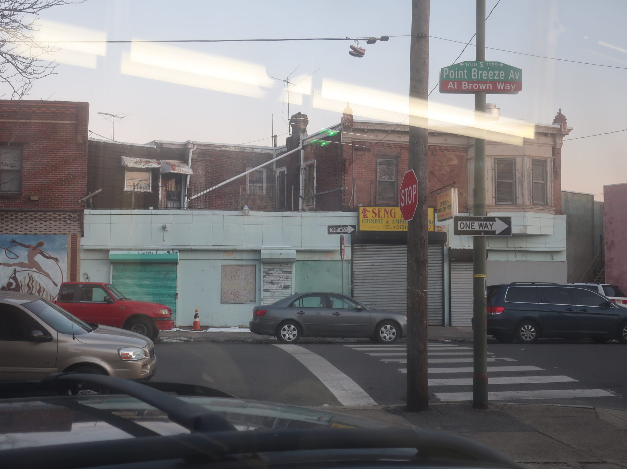
K (Ridge-Midvale to Arrott Transportation Center)
The K really is an odd duck in the SEPTA canon. Forming almost an upside-down U, this route is a crosstown across North Philadelphia that completely overshoots the Broad Street Line, running through some of the northernmost reaches of the city. Despite that, it manages to get pretty darn busy! This requires further investigation…

The K even starts weirdly: buses begin at the intersection of River Road and Midvale Ave in East Falls, a place where no other route starts. There was no one else on the bus as we took a right onto Midvale, running through East Falls’s small downtown before making our way up a twisty hill with rowhouses lining the road. A few more businesses were clustered around East Falls Station, then the road got incredibly leafy and lined with beautiful houses.

We had a brief one-block foray on Fox Street in order to get to Queen Lane, which aside from more houses, took us past the Drexel University College of Medicine. As we hit Queen Lane Station, the neighborhood finally started to densify and our first passengers started getting on. The street was now lined with denser rowhouses and people were getting on at a steady clip.

Some semi-detached houses returned when we took a left onto Wayne Ave, though, but a giant apartment tower did serve to offset that a bit. Some suburban businesses with parking lots showed up as we turned onto Chelten Ave, but they quickly morphed into a more constant affair: retail lined the road, culminating in some multistory buildings at the major intersection with Germantown Ave. Businesses continued from there in various forms as we passed Germantown Station, eventually supplemented by more semi-detached houses and eventually pure rowhouses.

We got more retail at the intersection with Chew Ave, and Chelten Ave got really diverse north of that, with rowhouses, businesses, a few churches, a school, and a park/recreation center. At an intersection surrounding a tiny triangular monument, Chelten Ave suddenly turned 45 degrees to head east; buses heading the other way use it, but we would continue straight on what was now called Wyncote Ave. This street passed some more businesses and houses, with similar scenery as we turned onto the wide 66th Ave.

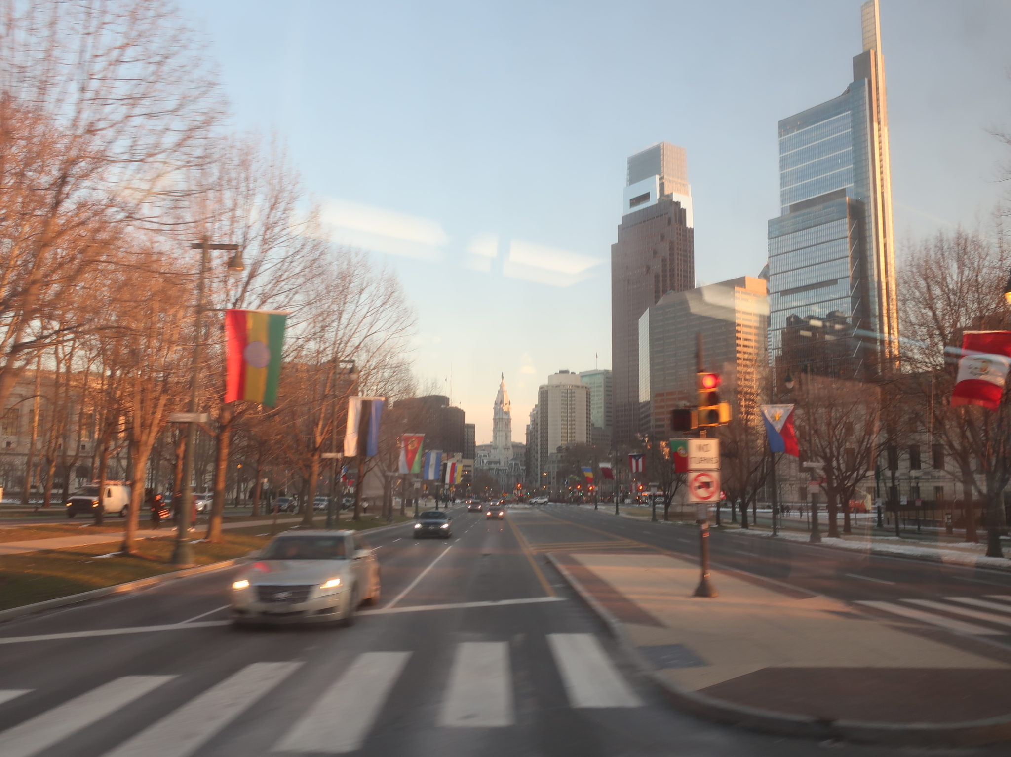
We eventually crossed Broad Street about a mile north of the Broad Street Line’s northernmost station on it, Olney. East of there, it was a very sudden shift to lower-density housing, as the street became lined with big single-family homes and a ton of trees. Some rows returned as we made a right onto 5th Street and passed the Oak Lane Reservoir, then we turned onto Godfrey Ave less than half a mile from Fern Rock Transportation Center as the crow flies (but because of the street system and station layout, a significantly longer distance by walking).

Well, on Godfrey Ave, density was back: rowhouses for days along here! A suburban shopping plaza and a school appeared when we turned onto Front Street, but it quickly became dense houses again, continuing as we took a right onto Champlost Ave. Well, at least until that street curved its way into the woods. This was just a brief jaunt into the small forested area surrounding Tacony Creek, and once we turned onto Adams Ave and crossed it, we were back in civilization.

Civilization, as it turned out, meant a giant factory, a giant shopping plaza, and a giant apartment complex. Sure, there was a brief section of rowhomes after that, but it was back to suburban businesses as we made our way onto everyone’s favorite road, Roosevelt Boulevard. Luckily, this segment on the twelve-lane behemoth was short: we pretty quickly merged onto the dense, residential Foulkrod Street (where the speed limit for buses, according to the signs, is as low as 5 MPH. 5 MPH!!!!). As we approached the El, one final right turn onto Oxford Ave led us to the dropoff at Arrott Transportation Center.

Route: K (Ridge-Midvale to Arrott Transportation Center)
Ridership: Yeah, for a pretty bizarre route, it’s interesting that the K hits the top 30 for ridership: it’s the 26th-busiest on the system, nabbing 8,448 riders per weekday. Even my Sunday trip was decent, with 37 riders over the course of about an hour. It’s noteworthy that the bus was empty from East Falls to Queen Lane, but even so, that part of the route serves as an important connection, and East Falls is the best place to turn the bus around, anyway.
Pros: It’s honestly amazing to me that this strange upside-down U of a route that doesn’t even touch the Broad Street Line can get so much ridership, but I’m so proud of it! Unfortunately, I don’t have a ton to say about the schedule that belongs in this section, but the every 7-10 minute peak headway is nice, as is the roughly every 12-15 minute schedule on weekdays and roughly every 20 minute schedule on Saturdays.
Cons: SEPTA is usually pretty good about keeping consistent headways, so I don’t understand why this route has such weird ones! On weekday midmornings, the range is from every 15-17 minutes, while on Saturdays, it’s every 19-21. The Sunday schedule is roughly half-hourly, which is subpar anyway, but it doesn’t help that it actually ranges from every 29-32 minutes (and it’s even worse at night, ranging from every 30-37 minutes)! The layovers are all over the place, too – on Saturdays, for example, the time the bus spends at Ridge and Midvale ranges from seven minutes to twelve minutes, changing trip by trip. If the layovers could be more standardized, the schedule could probably be more consistent! Also, while I can’t find any data on productivity specifically, the K almost certainly runs more frequently at rush hour than it has to – the load profile shows a few packed midday trips (probably school runs) and late trips (no idea why those are so busy!), but rush hour is not any more crowded than other times. Buses could be taken off the route during those “peak” hours to improve service middays and weekends.
The routing itself has a few odd aspects too. The fact that it splits into two one-way segments around the western portion on 66th Ave makes very little sense to me – all the main roads in that area are two-way and wide enough for buses to pass, so it feels really unnecessary to put the two directions a four minute walk apart. I would opt for having both directions take what the eastbound currently does: Wyncote to 66th, a much simpler trip than the westbound route, which has to do an awkward jog onto Stenton Ave. Speaking of awkward jogs, what’s up with the route’s deviation on Front Street and Champlost Ave just to the west of Tacony Creek? Running it straight down Godfrey would make a lot more sense, especially when the deviation doesn’t serve anything not within a short walk from there, and it’s doubled by the 57 anyway.
Nearby and Noteworthy: East Falls is great, Germantown is great, and there are neat-looking ethnic restaurants (Caribbean, Korean…) along the whole route.
Final Verdict: 5/10
I really have a lot of respect for the K, and I think that positively affected the score. This is such a bizarre, underdog route that clearly serves an important crosstown purpose, and that’s reflected in the ridership. But this has to be one of SEPTA’s craziest single-variant schedules, what with the bizarre headways, and the routing has quirks that make no sense. With some streamlining, the K could be really good, but as it stands, it’s mediocre at best. Or, as some might say: it’s O”K”. HA!
Latest SEPTA News: Service Updates
BRTA: 15 (West Pittsfield/Lebanon Ave)
The 16 interlines straight into the 15, so I wasn’t able to get a proper shot of the bus! Shoot.

We headed out from the ITC onto the highway-like Center Street, passing some suburban businesses before turning onto Housatonic Street, whose retail had smaller parking lots. There were houses along here, too, and relatively dense ones at that. A major stop along the route is “Pittsfield Plaza”, which is now…entirely dedicated to a U-Haul center. Yeah, probably not generating a ton of ridership from that.

We got some forest after the plaza, but a few side streets had houses along them. The street became a bit of a hodgepodge, with residential sections, as well as some businesses, a few hotels, and some industrial buildings – that last one especially as we turned onto Lebanon Ave. We used this mostly house-lined street to loop around and head back to Pittsfield.

BRTA Route: 15 (West Pittsfield/Lebanon Ave)
Ridership: These short Pittsfield-based shuttle routes all seem to get similar levels of ridership, and the 15 fits into that mold nicely, with around 62 passengers per weekday and 15 per Saturday. That equates to around 5 people per round trip on weekdays (which isn’t awful given that the BRTA is rural and the round trip is just half an hour), but mine got a whole 10!
Pros: Standard BRTA stuff: an hourly service on weekdays, a defendable bi-hourly service on Saturdays, and a direct route serving a bunch of houses and a few workplaces.
Cons: Nothing like a by-request deviation to a historical museum! If someone actually takes the BRTA to the request-only stop at Hancock Shaker Village, you have my blessing.
Nearby and Noteworthy: Besides Hancock Shaker Village? Nothing much.
Final Verdict: 5/10
I’d put this in the same boat as the 11, but unlike with that route, the 15 doesn’t really have any anchors that could potentially drive ridership up. Maybe transit vouchers for employees at the few factories near the end of the route, but other than that, it’s really just houses. The downfall of Pittsfield Plaza surely didn’t help matters here.
Latest MBTA News: Service Updates
Girard (BSL)
I reported this to SEPTA, so it isn’t an issue anymore, but the station page for the Girard Broad Street Line station showed a map of the Girard Market Frankford Line station! See, this is why you don’t give your stations the same name, because stuff like this happens! Once this post is done, though, I’ll have reviewed every SEPTA station called Girard. What a milestone.

Girard is one of the most well-served stations on the Broad Street Line, since all three service patterns stop here: locals, expresses, and the Broad-Ridge Spur. This is the southernmost station where everything’s on the same main line, too, so you end up with a few odd, not-publicized connection opportunities. On weekdays, many northbound locals meet up with northbound expresses, while on Saturdays, every Broad-Ridge Spur train is supposed to meet with a local (delays notwithstanding, of course).

But other than the timed meetups here, the platform at Girard is standard BSL express stop fare. While the tracks are full of gunk and the paint on the walls and ceilings is chipping away, the platform itself is pretty clean, with some appealing tilework on the pillars and plenty of places to sit or throw out your trash (although clearly some people still prefer to use the tracks). The staircases have some neat artwork to give a bit of a unique flavor to the station, though.

Girard has two mezzanines, but the one on the south side of the intersection is only open from 7:30 AM to 4:00 PM, weekdays only (at all other times, it’s exit-only)! I mean, according to the faint older sign, it was at one point only open from noon to 4:30, so I guess it’s improved since then? The current hours are still bad, though – at least it’s only a matter of crossing the street to get to the other entrance, but people still manage to fare evade here anyway by wrestling open the emergency door (admittedly small sample size: two people I saw while I was here). Clearly it’s gonna happen whether you keep the entrance open or not, so why not just keep it open?

The other mezzanine is where the elevators go, but annoyingly, they drop you off slightly below ground level, so elevator users have to ascend a few steps or a ramp once they get up here. Again, the classic SEPTA hallmarks are here: a few benches to wait at just inside fare control, a too-small number of faregates and fare machines, and some outdated AT&T signage. The ramps to the elevators have some more of that cool staircase art, though!

One elevator and two sets of stairs lead to street level. Aside from one entrance to the bad mezzanine that’s just a staircase in the ground (which frankly makes sense – they shouldn’t be advertising that thing given its opening hours), Girard’s entrances have a nice aesthetic to them. It’s not unique to this station, but I still like the way the shelters feel like they’re bursting out of the ground.

The connections here include the 4 and 16, because of course they do, but these subway-paralleling routes actually get shelters in both directions! There’s also a connection to the 15, which in the westbound direction gets a proper median stop, while in the eastbound direction it’s just a standard roadside stop…with no shelter. C’mon, the 4 and 16 get one, but not the far busier 15? Boo! Not that the median stop is any better when it comes to putting a roof over people’s heads, of course.


Station: Girard (BSL)
Ridership: This is one of three stations on the Broad Street Line that gets the max number of trips every day (596!), but it’s by far the least-used of the three. Just over 4,000 riders per day is decent enough ridership, although once you factor in how many trips a day it gets, it averages out to under 7 boardings per train. I guess local-to-express transfers might throw in a few extra riders here, but generally this is not a super busy stop.
Pros: Aside from your standard pros, like a decently clean platform, nice entrances, and wheelchair accessibility, Girard stands out with its neat staircase art.
Cons: The entrance on the south side of the station being closed evenings and weekends is the big one for me, especially when people still seem to fare evade in there anyway – presumably that’s the reason they keep it closed, but it doesn’t seem to be helping much, so I say just leave it open sans cashier. Other problems are smaller, like the dirty tracks, the sunken elevators, and the lack of a shelter for the westbound 15. Also, it would probably make more sense for this to be a local-only stop and for Cecil B. Moore to get express service, but we’re long past the point where that kind of infrastructural change can be made…
Nearby and Noteworthy: Lots of fast food chains surround this one intersection: take your pick from McDonald’s, Checkers, or KFC! Or if you’re looking for a real place to go, this is the closest stop to The Met Philadelphia.
Final Verdict: 6/10
For all intents and purposes, this is a fine station. It’s accessible, it gets a ton of service, and it’s in a sensible location – what more could you want? Aside from that entrance being open more, the elevators being raised a little bit, and the express stops making more sense, that is. 6/10 seems about right.
Latest SEPTA News: Service Updates
BRTA: 16 (Allendale Shopping Plaza/Crane Ave)
Yikes, Crane Ave is the main street on the 16, and it offers pretty much nothing transit-oriented aside from one apartment complex. That’s the breaks when you’re running a system as rural as the BRTA, I guess…

The initial section on North Street was urban, though, since we were right downtown – that benefit was dampered, though, by the fact that there are three other routes that go this way. The 16 is the only one that actually deviates into the Berkshire Medical Center, probably because it gets the least ridership out of any of the buses on this trunk, so the deviation inconveniences the smallest amount of people. It was north of the hospital that we broke free from the other routes, running alone on Route 7 past a bunch of leafy houses and the giant Springside Park.

We turned onto Crane Ave, the route’s main street, but a dense residential neighborhood lasted just a few blocks before devolving into spread-out houses with no side streets. Oh, and two golf courses. Across the street from each other. The small Oak Hill Apartments complex was pretty much the only thing along here that could conceivably justify sending a bus this way. Crane Ave eventually led us to the mall complex in northeastern Pittsfield (served by many other routes), and a deviation into the Allendale Shopping Center ended the trip.

BRTA Route: 16 (Allendale Shopping Plaza/Crane Ave)
Ridership: Among the lowest on the system, getting about 57 riders per weekday and a mere 19 per Saturday. The full trip takes just 15 minutes, though, so that slightly offsets the incredibly low passenger numbers.
Pros: This route is verrrrryyyyyyy political. Serve an entire street just to get one apartment building? Alright, fine! Granted, these routes serve a coverage purpose and very hard to get rid of, and the 16 provides a decent hourly weekday service to the places it goes.
Cons: Five trips every two hours on Saturdays is sad, but what are you going to do when ridership is so low? The 16’s biggest problem, though, is that it just doesn’t really do enough to justify existing on its own. Because the 1 and the 4 run so close together during their Pittsfield sections, it could be possible to have one of them go via Crane Ave (it wouldn’t take much longer – if anything, it might be slightly faster) and eliminate the 16 altogether. Essentially no places would lose service, and the extra bus could be used to increase frequency somewhere else.
Nearby and Noteworthy: If you like golf, have I got the route for you.
Final Verdict: 3/10
For a political route that pretty much has to exist to serve the Oak Hill Apartments, I can’t fault the 16 too much. Yes, I gave it a 3, but it’s not an angry 3; it’s a pity 3. The 16 gets a pity 3. Poor 16.
Latest MBTA News: Service Updates
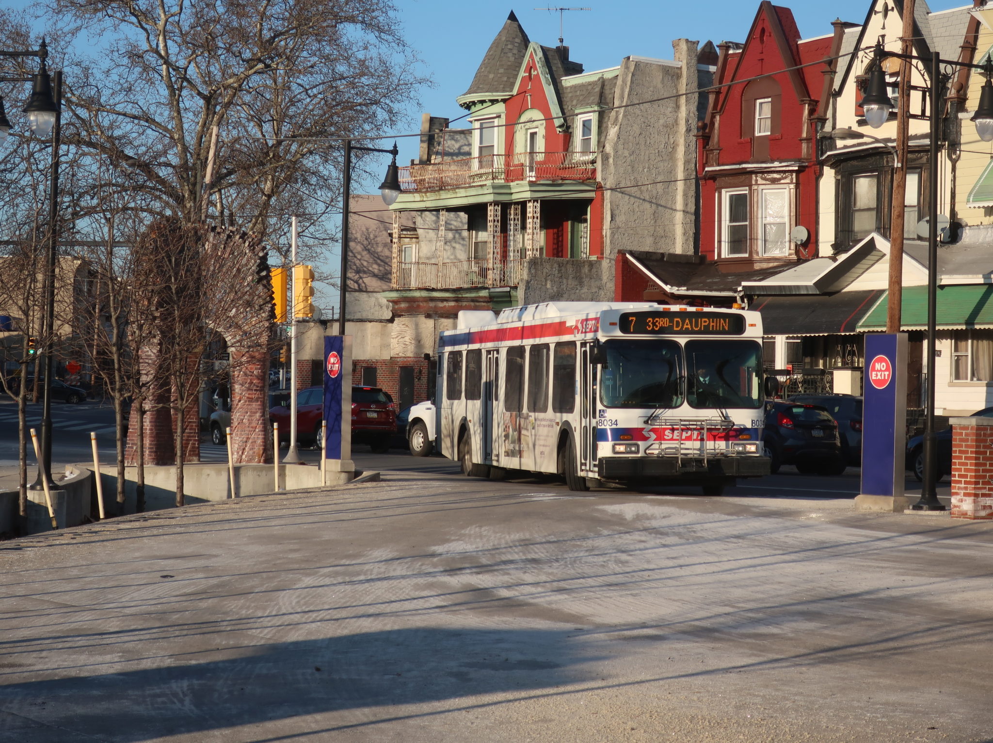
7 (Pier 70 to 33rd-Dauphin)
Oof, this might be one of SEPTA’s most beastly City Transit routes. It doesn’t get much crazier than taking a convoluted path from North Philly down into Center City, onward to South Philly, across to the other side of town, and then back up to serve the South Philly malls area. Sure, there are a few routes that may be more insane, but the 7 is a contender regardless!
Things started out ominously, with the northbound trip coming into the 33rd-Dauphin Loop late enough to already have to depart for the southbound behind schedule. We left the loop as quickly as possible, running down Dauphin Street past the Strawberry Mansion High School, some sizable vacant plots of land, and rowhouses of varying structural quality. There was a small mall at the intersection with 29th Street, which we would eventually turn onto, but first we had to do this completely nonsensical jog out to 26th Street.

What extra things did we serve by going out to 26th Street? A few more abandoned lots, a few more rowhouses, and a giant field that, according to Google Street View, is where some of the Strawberry Mansion horses are kept (I didn’t see any on the cold winter’s day I rode the 7). Also, this is all covered by the 39! Anyway…we took Susquehanna Ave to return to 29th Street, turning onto it to follow the 48 and 49.
29th was a major two-way street, but it was still mostly residential, although there was some retail at the intersection with Ridge Ave. Some industry showed up as we crossed the Northeast Corridor, and the rowhouses continued on the other side, still occasionally punctuated by some vacant lots. The lots started to disappear the further south we got, though, and eventually it was just a constant stream of multicolored apartments on both sides of the road.
Girard Ave was the real hotbed of gentrification in this area, with its hipstery restaurants and shops. It also marked the boundary between gentrifying Brewerytown and long-past-gentrified Fairmount, which was mostly well-kept rowhouses, along with corner businesses. We used Pennsylvania Ave, which runs alongside Fairmount Park, to make our way onto Brown Street, continuing through the neighborhood.
We turned onto 23rd Street next, getting a view of Eastern State Penitentiary across a parking lot. Fairmount Ave was a major retail corridor that we crossed before we suddenly stopped at Green Street: buses were detoured onto Green because of utility work, and a 48 had gotten stuck trying to make the turn. The driver put the parking brake on and got out to guide the bus ahead, helping its driver weave its way onto the tiny Green Street. The process took ten (ten!) minutes.

We made it a block down Green before inexplicably stopping again, this time at 22nd. The driver got out and actually chocked the bus, so it seemed we’d be stuck here for a while. He walked down the street and was gone for about eight minutes before coming back – maybe it was to help that 48 make the next turn? Meanwhile, our bus was getting honked at because cars couldn’t pass on the one-lane road. They eventually caught wind of the situation and started backing up to turn off earlier.

The driver finally came back and we continued to 21st, where after crossing Spring Garden Street, the rowhouses turned to modern apartment buildings. We rejoined the regular route as we reached Ben Franklin Parkway, going right by, like, all the museums: the Rodin Museum, the Barnes Foundation, and the Franklin Institute, as well as I-676 (a museum about how to destroy several neighborhoods). Still, 21st Street reverted to rowhouses again until we reached Arch Street and the Regional Rail tracks, where it was Center City skyscraper time.
In this part of Center City, the tall buildings are mostly concentrated on Market and don’t stretch too far to the south or north. We took a right on Market, passing the 22nd Street trolley station, and then we turned onto 23rd Street, where a massive crowd was waiting at the stop. The driver opened both doors. “Folks, I’ve got another 7 about two minutes behind, but you can hop on the back if you want.” We were standing room only as we continued into South Philly.
By the time we got down to Walnut Street, the buildings had reverted back to three-story apartments. The few businesses that did appear were geared toward the local community, like laundromats. We passed beautiful Fitler Square at Pine Street, then at South Street, another small square was surrounded by businesses. And now, we had to do another detour, so we used Greys Ferry Ave to get to 24th Street, a block away from the regular route on 23rd. At least it didn’t involve any impossible turns.
It was still mostly rowhouses along here, but a beautiful, abandoned school building proved to be an interesting sight. A bunch of industry showed up as we approached Washington Ave and took a left, taking the massive road one block in order to rejoin the regular route on 23rd. The row homes came back, along with a few churches and another vibrant park, Wharton Square.
Aside from a few businesses at major intersections, it was pretty much all residential along 23rd Street as the bus slowly emptied out. The nice, dense neighborhood ended abruptly at Passyunk Ave, which we turned onto for a block to get onto 24th Street, running past a suburban shopping plaza and an electric substation. While one of the many plazas around here seems like a relatively logical place to end the route, it just has to keep on going – now it was time to take a left onto Oregon Ave for the crosstown section!
Oregon Ave was a wide road with a median (and a bunch of cars parked in it, of course!) that ran past a ton of shopping plazas and businesses with parking lots. Eventually it did revert to two-story rowhouses and businesses, but they looked really dinky on the five-lane-plus-parking road. We crossed the Broad Street Line at Oregon Station.
Continuing east, the north side of the street was lined with retail, but nearly everything else was residential. The dense mass of buildings broke around 5th Street, where we went by Whitman Plaza, some businesses with parking lots, and a recreation center. As soon as Oregon Ave went under I-95, we entered a vast industrial wasteland. It was now time to return north to serve the South Philadelphia malls, so we turned onto Weccacoe Ave.
Columbus Commons, with its IKEA and Lowe’s, appeared amongst the industry – or the back of Columbus Commons, anyway. Gotta love that grassy stop in the backlot of the IKEA. More shopping plazas abounded as we turned onto Snyder Ave, then Water Street, running next to the elevated I-95. We took this all the way up to Tasker Street before coming back around onto Columbus Boulevard, returning south past, yes, more shopping plazas. We pulled into the Pier 70 shopping center to end the run, and surprisingly, despite all of the stops and detours and the fact that another 7 was directly behind us, we ended up arriving only 17 minutes late!

Route: 7 (Pier 70 to 33rd-Dauphin)
Ridership: The 7 gets nearly 5,000 riders a day, but because it’s sooooooo long, it ends up being only marginally productive. An average of 47 riders per 70-minute trip is okay, but not great. Of course, my cursed ride snagged 77 riders over the course of its duration, but since it was the evening rush, the vast majority of those riders went from Center City to South Philly.
Pros: There’s certainly no denying that the 7 serves a lot. It also deserves praise for being mildly more productive at rush hour than midday, something that many SEPTA routes can’t say. It runs at a decent every 15 minutes during those peak times, while its weekend service is surprisingly decent, with 20-minute headways on both Saturdays and Sundays.
Cons: This route is a BEAST! A MONSTER! And so much of it makes no sense! The entire North Philadelphia section pretty much parallels the much-more-frequent 48 and 49 (minus a few dumb deviations that shouldn’t be there), while the Oregon Ave section pretty much parallels the much-more-frequent G (minus the fact that the G doesn’t go all the way to Pier 70 for whatever reason). So as far as unique sections go, the only place this route really is a necessity is on the north-south South Philly section. Also, the route becomes infrequent really early in the day, especially on weekends, and why is it every 25 minutes weekday middays?? The load profile clearly shows that many of the highest-ridership trips are midday. Could this be the only SEPTA route that runs better service at 8 AM on a Sunday than it does at noon on a Tuesday? What gives?
Nearby and Noteworthy: Well, as far as the route’s actual unique section goes, Fitler Square looks really nice and charming. There are also a number of neat local businesses up and down 22nd Street, which is where the northbound route travels.
Final Verdict: 4/10
Alright, welcome to my radical 3-step proposal to make the 7 less insane:
Step 1: Make the northern terminus 30th Street Station. I know this would be a sacrilegious move, but very few people travelled across Market on my trip (could be different on others?), and that small amount of riders could transfer to the 48 or 49 to continue north.
Step 2: Make the southern terminus Quartermaster Plaza, the main shopping plaza around Passyunk and Oregon. Having the 7 and the G both run down Oregon Ave with uncoordinated schedules isn’t helping anyone (in fact, on Sundays when both routes run every 20 minutes, they’re scheduled to be directly behind each other).
Step 3: Use most of the gained resources from shortening the route to make it more frequent. A one-way trip would only take half an hour now, so it would only require maybe five buses tops to operate it every 15 minutes. The route currently uses eight buses middays, so there would be three buses to spare for boosting service on the G and the 49.
The end!
Latest SEPTA News: Service Updates
VIDEO: I Took Three Greyhounds and an OurBus to Nashville
With plenty of time for shenanigans along the way! (filmed before the Longest Bus Ride video)
BRTA: 11 (Berkshire Community College)
Alright, the 11 is short and sweet, so let’s just get into it.

This route heads straight west from the ITC, meaning we didn’t have to deal with downtown Pittsfield at all. We made our way straight onto College Way, which turned into the mostly residential West Street. A church and a school showed up along here, but it was mostly houses. Eventually we used Tor Court to deviate up to the Berkshire Medical Center Hillcrest Campus, then it was back to West Street, where the houses were getting further apart and set back further from the road (which now had no sidewalk). Just as the scenery started to change to open fields, we pulled into Berkshire Community College to end our incredibly short trip.

BRTA Route: 11 (Berkshire Community College)
Ridership: This route averaged just 45 riders per day in 2017, meaning a little over four people per round trip. Sure, that round trip only takes 26 minutes, but it’s still quite low.
Pros: I have a soft spot for short routes, and this one serves pretty much all you need to serve that’s along West Street. It has an hourly schedule all day, plus a recently added Saturday service that runs every two hours (although given the low ridership, the infrequent service probably makes sense). Also, late night service is provided in the form of the 11N, which I’m gonna have to review separately because it’s a completely different route…and it wasn’t running yet when I did all of these, so it’ll have to be in the future!
Cons: It’s too bad that the Hillcrest deviation is outbound-only, but that’s probably the best way to serve it in order to keep running times low. This route, like the 4 (since they interline) has an odd point midday where the departure times shift by 15 minutes. Finally, there’s the low ridership – I wonder if there’s ever been talks between the BRTA and BCC to provide free fares for students. I mean, the BRTA apparently provides free transit on your BIRTHDAY, so BCC doesn’t seem that far-fetched…
Nearby and Noteworthy: You’ve got a medical center, a school, and a bunch of houses.
Final Verdict: 6/10
The route effectively serves what it’s supposed to serve, but I think the problem is that people just don’t want to take it. One reason could be that because it’s so tiny, you’re almost guaranteed to have to transfer from somewhere else if you’re going to BCC. Free fares for students could mitigate that and get more people to ride the route – I’d imagine the bulk of its ridership is already BCC students, anyway.
Latest MBTA News: Service Updates
54 (Richmond-Cambria to 33rd-Dauphin)
For a relatively simple and relatively short North Philadelphia crosstown, my 54 sure did get packed. I guess we’ll find out at the end if that’s normal or not…

I got on an eastbound bus a few blocks from the end of the route and just stayed on to head westbound again. Even though the intersection of Richmond and Cambria is considered to be the first stop, we looped around to Richmond and Somerset to lay over. The stop was surrounded by dirt from the ongoing I-95 construction, while the highway overhead was the source of a ton of dripping mystery liquid. Great place to hang out!

Once we headed off again down Somerset Street, we immediately entered a real neighborhood after escaping the underbelly of the highway. The street was lined with well-kept rowhouses, along with occasional corner restaurants. Around Aramingo Ave, things took a turn for the industrial, with big scrapyards and abandoned factories appearing everywhere.

The houses came back as we approached the El on Kensington Ave. We turned to run underneath it as a triple-bunch of 54s passed in the other direction (yikes); the road passed a few businesses, a few houses, and a few industrial lots as it went under some train tracks. Once on the other side of the tracks, we turned onto Lehigh Ave, a four-lane road with one of those weird do-whatever-you-want lanes in the middle.

Temple University Hospital occupied a huge tract of land, but even the street’s smaller lots were diverse: there were rowhouses, of course (some with retail), but you also had some apartment developments and a bunch of comparatively newer retail with parking lots out front. Some fast food restaurants and an abandoned supermarket showed up at the intersection with American Street, and a few blocks later, we passed a park opposite an elementary school.

At 5th Street, we passed some fake palm trees radiating from the wonderful Centro Musico, previously seen in our 39 review. A beautifully renovated library appeared at 6th Street, then after a supermarket, we got rowhouses for a stretch (plus some striking churches and cathedrals). Unfortunately, there were also vacant buildings and empty plots of land along here, too.

We crossed Broad Street at North Philadelphia Station, where the driver opened all the doors and it was an absolute free-for-all for the massive crowd of people waiting to get on. There were a few blocks of rowhouses and corner stores from there before we crossed under the Northeast Corridor and went by a park, a modern-looking church, and a grocery store. The rows returned after that, though, with many of them featuring businesses on the ground floors.

Many of the buildings or lots were empty, but there were also signs of community investment, such as the second library on the trip, this one super new and modern. As we came alongside a cemetery, an interesting circular school showed up across the street from it. And it was at that point that we turned onto the residential 33rd Street, taking it for a few blocks down to the 33rd-Dauphin Loop.

Route: 54 (Richmond-Cambria to 33rd-Dauphin)
Ridership: The 54 has excellent weekday ridership for a short-for-SEPTA-standards route, with 7,662 average riders (about 51 per trip). It’s also noteworthy that this route has the 4th best farebox recovery on the system, recouping 48% of its expenses with fare revenue. Finally, I have to mention the insane number of people my trip got: 139 over the course of about 50 minutes. The afternoon school rush in Philly is something else!
Pros: Ah, it’s the little things in life – isn’t it lovely how Lehigh Ave is a two-way street, so the route pretty much cuts a straight line across North Philly that’s the same in both directions? Beautiful. You do have the one-way segments on the route’s Port Richmond section, but that’s unavoidable. Adding to the 54’s simplicity, all trips do the exact same thing, barring the first eastbound (which begins at Broad) and a few supplemental school trips. Ridership on this thing is clearly great, representing the importance of Lehigh Ave as a major commercial corridor.
Cons: So given that it’s ridership is so good…what’s up with the schedule? Every 12 minutes at rush hour is fine, but every 16-17 during the day? Every 20 on Saturdays? Every 30 on Sundays??? Don’t get me started on how the route is every 45 minutes by 8:30 PM! Maybe I’m missing something here, but this route seems too important to give it a schedule like that. At least make it every 15 throughout the weekday! And this unfortunately seems like a situation where we can’t even redistribute resources – maybe buses could be taken off the rush to bolster the rest of the day, but it seems like the frequencies they’re running at are necessary at least for the end of school, if my trip is any indication.
Nearby and Noteworthy: Now that I’ve gone by it twice, I really feel like I have to check out Centro Musico. From instruments to CDs, the place just exudes charm and is clearly a neighborhood staple!
Final Verdict: 4/10
That schedule is rough. There are routes far less productive than the 54 that run way more frequently! Getting the weekday schedule to every 15 minutes all day is a start, and then lowering Sunday headways to every 20 is probably step 2. And I get that this is a case where, at least within the route itself, there are no resources to move around. But I can always dream…
Latest SEPTA News: Service Updates
BRTA: 4 (Pittsfield/Dalton/Hinsdale)
Oh my gosh, what the heck were they thinking with this route and all its inbound-only deviations? “YOU get an inbound-only deviation, and YOU get an inbound-only deviation. EVERYBODY GETS INBOUND-ONLY DEVIATIONS!!!!!!!!” Needless to say, the outbound 4 trip to Hinsdale, a town I had never heard of before this, was much faster than the eventual inbound.

We didn’t have any time to experience Hinsdale because the bus just turned right around when we got out there. There isn’t much to it, though – it’s just a collection of a few buildings with a post office, one restaurant, a bank, and a library that Wikipedia tells me is “a rare early example of French Tudor style imported to North America.” Neat!

We made our way onto Route 8 from downtown, a road which quickly devolved into woods with a few occasional houses as it paralleled the Lake Shore Limited train tracks. The road entered Dalton along this section, and we soon entered civilization: houses showed up along the road, and we passed a middle school and a few scattered, basic businesses. Now, according to the BRTA’s data on Google Maps, the 4 now takes a different inbound deviation from what it did when I rode in summer 2018 (oof, daily reminder of how behind I am), but I’m going to tell you about the one it did on my ride – they’re both meant to serve the same thing.

We stayed on Route 8 up until downtown Dalton, which began with some businesses and an abandoned factory along a river. After that block, we turned up onto North Street, making our first deviation, whose purpose seemed to be to get closer to a small apartment complex. Other than that, it was almost all houses along here, and we used the tiny Franklin and Pleasant Streets to get back to Route 8.

Coming back on the main road, there were a couple of gas stations, a few businesses, and a post office before some municipal buildings showed up further down. Our second deviation involved several more residential streets: it was a loop involving Curtis Ave, High Street, and Park Ave that was meant to serve another small apartment complex. Coming down Park, we passed a school and a cemetery, and the return to Route 8 brought us past houses and forests.

We passed an apartment development, and then it was time to enter the mess of malls in northeastern Pittsfield. First we deviated into Berkshire Crossing, a series of strip malls, then we used Merrill Road to serve some more retail with giant parking lots. This took us into an industrial area, where we turned onto Plastics Ave and went by a few factories.

Unlike the 1, which from here travels straight to the Intermodal Transit Center via Dalton Ave, the 4 has some more deviating to do. We curved our way up to the Rose Manor apartment complex, which we actually went into and looped around this time. This is an inbound-only deviation according to the horrendously outdated route map, but apparently outbound buses do now serve it. We headed toward the ITC on the residential Elberon Ave, a block away from the 1’s routing.

As Elberon turned into Springfield, the houses got closer together. We ran along the huge Springside Park before turning onto North Street outside of the Berkshire Medical Center. There were businesses along here, and as we got closer to downtown Pittsfield, the buildings got taller and denser. Finally, we turned into the ITC.

BRTA Route: 4 (Pittsfield/Dalton/Hinsdale)
Ridership: It’s the fourth busiest on the system, with 184 riders per weekday and 90 per Saturday. Given the steep drop from weekday to Saturday, I wonder how much of this route’s ridership is people commuting on weekdays from Hinsdale and Dalton into Pittsfield, whether it be to retail jobs, industrial jobs on Plastics Ave, or…office jobs? Does Pittsfield have any? Probably not many…
Pros: I guess as far as connecting Dalton and Hinsdale to Pittsfield goes, the 4 does about as well as it can do. The route runs hourly on weekdays, a standard schedule.
Cons: Huh, another reason Saturday ridership is so low could be the fact that it’s every two hours. Hmm. It’s also odd how on weekdays, the departure time randomly shifts from being on the :05 to the :20 in the middle of the day. Why? Even if it’s for a lunch break or something, does the BRTA not have enough employees to have someone swing on and allow for consistent departure times? Also, I have to talk about the inbound deviations: while I think that they’re a necessary evil in order to serve the more transit-oriented locations in Dalton, it’s also incredibly inconvenient that they’re inbound only. It probably has to be that way for scheduling purposes, but it’s still annoying for outbound passengers trying to go to those locations – perhaps a (shudder) AM/PM setup would work better, where the deviations become outbound only after noon. Finally, it feels redundant to have this route run a block away from the 1 on its inner portion; if the BRTA wanted to streamline things, they could extend the 16 to Hinsdale and cut the 4 entirely, but Rose Manor would lose service, and for all I know, maybe the houses a block away generate decent ridership anyway.
Nearby and Noteworthy: Neither Dalton nor Hinsdale had downtowns that felt particularly worth visiting, but Dalton is home to the Crane Museum of Papermaking – sounds neat!
Final Verdict: 4/10
This feels like a route that’s confined to never get above maybe a 6. It has so many necessary evils, from needing to serve the apartments in Dalton somehow, to needing some way to get from the mall area into downtown Pittsfield, even if it requires running a block away from the 1. As you can tell from the long Cons section, I think there is plenty of room for improvement here, but even at its best, the 4 will never be a 10/10 route.
Latest MBTA News: Service Updates
15 (63rd-Girard to Richmond-Westmoreland)
Yeah, yeah, save the comments. I’m, what, six days late? I mean, technically five days, if you count the fact that a 15 trolley ran at, like, 12:30 AM on Saturday, thus allowing SEPTA to claim that they ran that day and service was “officially” ending Sunday. Thanks for that, guys. I’m just glad I got to ride one Friday night, too.

But shall I first back up and explain the 15’s troubled history? Like almost all SEPTA routes, the 15, which runs across Girard Ave and then up into Port Richmond, started out as a trolley before any of us were born. In 1992, along with two other trolley routes, the 15 was “temporarily” turned into a bus; it took 17 years and a lot of political pressure to get the trolleys back, with their return coming in late 2005 (the other two lines are still bus – temporary indeed).

But now, we’re back at a similar juncture: ostensibly due to bridge construction, but also due to deferred maintenance on the 1947 PCC trolleys that run on the line that has led to just four being able to pass inspection, the 15 has been “temporarily” converted to buses. Even though I’m confident that trolleys will return to the line, who knows how long it’ll take – will SEPTA actually bring its PCCs back up to snuff, or will they wait until their trolley modernization project ten years down the line to bring new trolleys to the route? Regardless, this was the last time we’d be seeing SEPTA’s PCCs on the road for at least a while, so some friends and I went out to do final rides in the last week.

And this ride, the one I took pictures for, was on Thursday night. My friend and I waited at 63rd-Girard for a while for an actual trolley to show up (it was majority buses), and when one finally did come, it turned out it was going out of service. Luckily, another pulled in soon after, and we hopped on to head east. The route starts out in a bit of an industrial area, but rowhouses abound, too.

At Haverford Ave, we joined up with the westbound line (the route ends in a loop) at a crazy intersection with a bunch of tracks going every which way. Rowhouses were everywhere as we continued down Girard, picking someone up at pretty much every block. Some businesses appeared on the corners, while a park and a cemetery broke up the constant stream of two-story buildings.

Outside of a striking Checkers (and some other suburban-feeling businesses), we proceeded through the fun part of the route where it joins the 10 on Lancaster Ave for about 150 feet before turning back onto Girard. We passed a few schools before crossing the Pennsylvania Main Line, after which the tracks moved to the center of the road. While it’s nice that there are proper ADA stations here, even if they’re still just platforms with nothing on them, it’s bizarre to me that they’re still spaced a block apart so you’re still stopping all the time. Also, cars drive in the center lanes even when they’re not supposed to, and the lanes often double as left-turn lanes, slowing trolleys down when cars have to wait in front at green lights to turn.

Also, on my Friday night ride, we got to experience the fun of loading a wheelchair passenger along this section. While it’s great that SEPTA’s PCCs are wheelchair accessible (unlike the system’s other, newer trolleys, ironically enough), the wheelchair lift process takes forever. The driver has to make multiple trips to and from their seat to the back door to rig the thing up properly. We timed it out: it’s about a three-minute process.

Soon after passing the fantastically-titled School of the Future, we went by the parking garage for the Philadelphia Zoo, which was lit up in a vibrant blue color at night. I appreciate that for the 15’s zoo stop, they did actually give it a shelter with a little bit of vibrancy, probably for the three tourists per year who actually take the 15 to get here. As we crossed under the Northeast Corridor, a beautiful zoo-themed mural adorned the bridge.

Immediately after the zoo, we crossed I-76 and the Schuylkill River, offering a fantastic view of Center City. It’s also one of the few places on the 15 trolley that has enough of a nonstop section that it can get to a similar speed to the surrounding cars. We ran through the edge of Fairmount Park before re-entering rowhouse-land, this time amongst the breweries and cafes of gentrifying Brewerytown.

One of my favorite parts of the 15 came next: the bit where the tracks split into two one-way sections to make their way around Girard College. It’s just a blast when the trolley unexpectedly squeals its way around this tight turn onto the tiny one-way 26th Street. Granted, the westbound route uses two-way roads the whole time, so this 26th Street routing is technically unnecessary, but who cares, it’s neat! We took 26th for a block before another screechy turn onto Poplar Street.

We merged onto College Ave as we passed the sprawling and fancy Girard College campus, which I recently discovered isn’t actually a college, but an elementary/high school. College Ave turned back into Girard Ave, running past a few more specialty schools, as well as many more rowhouses and apartments. Pretty much everyone on the trolley got off at Broad Street, presumably to get on the Broad Street Line, but it was far enough past the evening rush that few people got on to continue east.

Some fringe Temple University buildings showed up here, but at this point, the businesses on Girard got rather austere and suburban-feeling (just like the neighborhood of single-family houses directly south of us). 9th Street was home to the elevated Regional Rail viaduct carrying the SEPTA Main Line, then as Girard narrowed a bit, it became lined with rowhouse structures again (often with businesses on the first floor). It didn’t take long for some big modern apartment buildings to start showing up, signifying that we were entering Fishtown.

Front Street was where the Girard El station was, but the trolley was empty enough that it didn’t make much of an impact on ridership. Girard Ave curved northeast, but just after that, we turned onto Frankford Ave to head to the 15’s temporary loop – because of the ongoing I-95 construction in Port Richmond, the 15 has been relegated to a terminus at Frankford-Delaware for years. The road took us past several bars, under I-95, and past The Fillmore before we pulled into the Frankford-Delaware Loop.

Time for an intermission to review the loop! Yeah, I mean, as far as loops go, it’s…okay. There’s a shelter, some wastebaskets, and some bike racks. Its proximity to the casino gives it great ridership at certain times, but it can be dead at other times. And it has two major problems: first of all, no Key machine, which would be nice to have; and second of all, the route 15 map provided here doesn’t even show it as serving this loop, but rather as going all the way to Port Richmond! C’mon, SEPTA. The 25 and the 43 go by here too, but they just have signs. Overall: 5/10.

But we cannot simply end our 15 review at Frankford-Delaware! For now we must transition to the 15B, which runs from the Girard El station to Richmond-Westmoreland in Port Richmond! And no, I don’t think SEPTA is actually calling it that anymore, since now both legs of the 15 are bus. Except it does appear to be called that on System Status. Uhh…I dunno, let’s just go ride it.

It was Saturday afternoon that some different friends and I took the 15B. We had ridden the normal 15 to Frankford-Delaware and walked up to the 15B’s first stop after the El station, a center median stop at Girard and Frankford. Having made its little loop from Front Street to get onto Girard Ave, the bus rounded the corner from Frankford…onto the far right lane, skipping the median. We had to flag it down, cross in front, and board in the middle of the street!

Now, if you thought the bus skipping the center median was bad, just wait until you see how ambiguous the route of the 15B is. You’ve got the routing shown on the paper schedule, the routing in GTFS (which is used by apps like Google Maps and Transit), and then there’s the routing we actually took: AND NONE OF THEM ARE THE SAME. The System Status shows no detours, and I don’t think there was one on Saturday, either! But okay…the three routes at least start the same, by running down Girard past various businesses and apartments.

The discrepancies began as we approached I-95 when, instead of taking the ramp to Aramingo Ave like what the paper schedule and GTFS say we do, we stayed on Girard, running through the complete and utter wasteland of highway construction. BUT: as it turns out, the route we took is currently the only way of getting to Aramingo. Soooo…maybe SEPTA should update its maps? Especially the GTFS one, which isn’t difficult to do? Especially when this this routing does actually skip some stops on Aramingo? This ramp closure seems relatively long-term, so…might be a good idea…

We used Cumberland Street to get onto Aramingo Ave, but by that point, had we been following the GTFS data, we’d be on Thompson Street! Instead we stuck to the paper schedule, going up the wide Aramingo and passing suburban businesses on both sides. A park and some rowhouses showed up before we went under railroad tracks, and it was all rowhouses on the other side (plus corner businesses).

We took a right onto Allegheny Ave eventually, still following the paper schedule map. This road was a lot busier than Aramingo, with some big churches, a ton of businesses, and a park. And hey, once we got to the intersection with Thompson Street, we were back to following the GTFS routing, too! We turned onto Richmond Street, but now we had to stray from all the maps: because of the ongoing construction at the loop, buses make a big circle via Westmoreland Street, Bath Street, and Allegheny Ave that runs through an industrial area. We got off at the intersection of Allegheny and Richmond.

Route: 15 (63rd-Girard to Richmond-Westmoreland)
Ridership: It’s interesting how the 15 and the 15B actually serve very different purposes. The 15, with its 5,450 average weekday riders, acts not only as a crosstown route, but also as a Girard local bus, with a lot of people taking it for short trips. While the 15B does get local riders, its primary purpose is to be a feeder line, bringing people from Port Richmond to the El and getting 3,250 people per day. The 15 does get higher ridership, but the 15B ends up being much more productive given its significantly shorter length: the 15 averages about 28 passengers per trip over its roughly 50-minute runtime, while the 15B gets about 17 people per trip over the course of 18 minutes. The 15’s low-ish ridership actually surprised me – you’d think a frequent trolley route along such a dense street would get more people!
Pros: We’ll be talking bus versus trolley later, so these are just the pros and cons for the route itself. As far as pros go, it’s fantastic that this is just a route straight across Girard, and the 15B works well as a feeder, too. These things are frequent, as well: they both operate at least every 15 minutes seven days a week (!), with service every ten minutes at rush hour. Even at night, they run at least every 20 minutes until 11 PM on weekdays and 10:40 PM on Saturdays (Sundays it’s only until 8:20 PM, alas), plus there’s half-hourly Owl service! For any SEPTA route, that’s a great schedule.
Cons: Hoo boy. I really don’t know where to begin, especially given the new problems that have arisen with this new bus operation. Well, since I’ve complained about it enough, let’s start with the various routings SEPTA claims the 15B does: what the heck??? The fact that there’s even a discrepancy at all between various official SEPTA outputs is alarming, and it’s even worse that none of them are right. But no, it gets even worse than that: I don’t know what’s going on in SEPTA’s GTFS department, but I guess they decided that since both legs of the 15 are bus now, there’s no need to give them separate designations anymore. So…um…

WHAT IS THIS??? NO!!!!!!!!! For some reason, SEPTA’s GTFS feed now shows the 15 as one continuous route that deviates to Frankford-Delaware! This is completely inaccurate and misleading. If it’s any consolation, the times at least match up with the schedule, and the 15B is coordinated enough with the 15 that there aren’t any weird time jumps in here or anything, but still: these are operated as two separate routes. And not only that, the 15B boards on Front Street underneath the El. But if you look up directions involving that transfer, Google Maps is gonna tell you to board on Girard, because that’s what this fake continuous route does! They need to change this right away, and I wonder how many people have already been misled by it.
This also brings us to the other major problem with the 15’s new bus operation: SEPTA didn’t change the schedule at all. The first issue with this is that the buses travel faster than the trolleys (sorry, trolley fans, but it’s true – we’ll discuss this more later), meaning that vehicles are likely going to be early with this new schedule. Not only that, but SEPTA totally missed an opportunity here to streamline the ride for everyone. As much as I rag on about the incorrect GTFS feed, that’s closer to the ideal situation than what we have. Instead of running two separate 15s that are now both buses (because, you know, that’s not at all confusing, especially given the fact that operators will sign the bus for whatever they want; I’ve seen eastbound vehicles signed as Frankford-Delaware, Front-Girard, Richmond-Westmoreland, and even Richmond-Cumberland, which the 15 never even terminates at), they could’ve combined the two routes and given everyone a one-seat ride again. They would save vehicles from not having to have layovers at both Front-Girard and Frankford-Delaware, and combined with the lower running times from running buses, they could’ve created a schedule that provides more frequent service with the same number of vehicles.
Sigh…anything else? Oh, the stops are too close. As usual. And I find that hilarious, because the center median stops actually required infrastructure to build, and SEPTA still put one every block. Classic.
Nearby and Noteworthy: Girard has a ton of businesses along its entire length. From soul food places in West Philly, to cafes and breweries in Brewerytown, to fast food places around Broad, to the many bars and restaurants of Fishtown, to pubs and ethnic eateries in Port Richmond, there’s pretty much stuff anywhere along here! Also, if it was still running trolleys, I’d say the route itself is nearby and noteworthy, but…no, you’re just getting a bus now.
Final Verdict: 4/10
Look, if you had asked me to review this prior to the bus implementation, I probably would’ve given it a 7. It’s a direct route with a much-better-than-average schedule whose only pitfalls are the standard SEPTA problems: too many stops, mediocre Sunday service (although again, it’s much better than other routes), and the bunching problems that come with running a long-ish route down a busy street. But the way they handled this new bus routing drags the route down so much, from missed scheduling opportunities to confusing routings to completely incorrect GTFS, that I had to lower the score by a lot.
But now, it’s time for the part where I get cancelled: should the 15 be a trolley or a bus? Look, the PCCs are beautiful pieces of machinery. The architectural details, the sounds they make, the fact that they look really good in photos…I love these things as much as anyone. But they lose a lot of their luster when SEPTA treats them like buses, when they should be treated like trains. A trolley like this will only work if it’s separated from traffic; as it stands, the trolley lane often doubles as the left turn lane, so trolleys would get stuck at green lights waiting for cars in front of them to turn left. The bus can just go around them. Not to mention other problems like having to go slowly around curves, the stairs people have to climb up to get on board, and the incredibly long wheelchair process. It also doesn’t help that the trolley routing in Port Richmond stays (and will continue to stay, despite the opportunity to change the route) on Richmond Street, which sticks next to I-95 and the no man’s land around it. It’s more direct than the bus, but it’s barely serving anything.
Am I saying that the 15 shouldn’t be a trolley? No, not necessarily. But in order for a trolley to work, SEPTA needs to take major steps to ensure that they can move down the street with decent speed. This includes not only restricting the existing median portions to trolleys only, but also giving the trolleys their own lane along the rest of the route; consolidating stops so the vehicles can gain more speed between them; getting new, modern trolleys with level boarding (sorry, PCCs); and ideally changing the route in Port Richmond, although we’re past the point of no return on that one. And making the route more traversable by trolleys allows the benefits of trolleys to shine – not only do they look and feel great, but they also have higher capacities than buses. But if SEPTA doesn’t want to make the necessary changes…then I’m okay with the 15 staying a bus forever.
So with that totally-not-controversial message in mind, here are more PCC photos!!!


Latest SEPTA News: Service Updates
BRTA: 3 (Williamstown/North Adams)
Another North Adams-based shuttle, although this one is much straighter. Today we’re heading to the northwesternmost point of Massachusetts on the 3!

From the Main Street bus stop in North Adams, we looped around the block to the Mohawk Trail, deviating into good ol’ Big Y after we rounded the turn. Once back on the Mohawk Trail, we crossed the Hoosic River, effectively leaving downtown North Adams. The houses along the road were pretty close together, but there was very little development anywhere else around us.

Some industry appeared after we crossed the Hoosic River again, and after some houses (and a nice mountain view), we passed the Stop & Shop that can be deviated into by request (no requests today, luckily). More houses led us across the border to Williamstown, where some suburban retail greeted us. There were also a ton of hotels – this place has some tourist demand!

A crossing of the Green River took us onto Williamstown’s leafy main street lined with large houses set back from the road, but things were a little less ornate when we turned onto Cole Ave. We took a left onto Church Street, serving the Proprietors Fields apartment complex, then we used Southworth Street to get back to the main drag. It was now dominated by the various buildings of Williams College, and we took it as far as Field Park, just outside of the “Williams Inn” – the 3’s last stop.

BRTA Route: 3 (Williamstown/North Adams)
Ridership: Okay, I’ve gotta take this ridership data with a grain of salt: it was taken in August 2017, meaning school wasn’t in session at Williams College, where I would imagine a good amount of route 3 ridership comes from. In that month, it got about 111 riders per weekday and 101 per Saturday, although my summer trip seemed to show higher numbers than that – it got 11 riders one way and 5 in the other direction. So I think any way you slice it, this route may get higher ridership than what the numbers suggest.
Pros: This seems like the most sensible way to connect Williamstown up with the rest of the system. A direct route from Pittsfield would just have too long of a middle-of-nowhere segment to make a lot of sense, and this North Adams shuttle solution probably covers most local needs, anyway. The route has a consistent hourly schedule on weekdays and Saturdays, plus there’s one weekday trip to Pittsfield for Williams College students. Also, in Williamstown, you can connect to not only Peter Pan, but also the Green Mountain Express, a $1 local bus to Bennington, VT!
Cons: The route have a weird eastbound-only deviation to an apartment complex that’s right next to the main road anyway, and it also has an excessive amount of request-only stops. Some are schools, which should really just be added to the schedule in the form of school trips if they actually generate ridership, and others are just weird, like to the Clark Art Institute or to a Goodwill store that would be covered if the 1 was extended to North Adams. It’s probably because of these various by-request deviations that the route’s schedule has to be tremendously padded: our driver would purposely leave late from each terminus (up to ten minutes!) so he wouldn’t have to wait at the stops along the way. Also, the route’s GTFS data (used by Google Maps and other transit apps) strangely shows it ending on the eastern end of the Williams College campus.
Nearby and Noteworthy: Williamstown is a real gem of a Berkshires town, with a nice store-lined main street and many cultural activities at Williams College.
Final Verdict: 5/10
Unlike the 34, which was a loopy shuttle that wasn’t trying to be anything else, the 3 tries to be useful but falls a bit flat. At its core, it offers a convenient shuttle between Williamstown and North Adams, but the ridiculous padding needed to accommodate request stops that are likely barely used is annoying. I’m sorry, but how can a route where it’s necessary to leave ten minutes late just to end up on time by the end of the trip get a better score than this? Plus, it makes it look like a really slow option for potential users – what would be a 12-minute trip by car looks like a 25-minute trip by bus, according to the schedule, when it really only takes about 15!
Latest MBTA News: Service Updates
VIDEO: The Longest Bus Ride in America
As promised, on the blog’s seventh anniversary, here’s the video for the longest bus ride in America. Enjoy!
Stadium (NHSL)
For our first review on the wild and wacky Norristown High Speed Line (I’m shocked it’s taken this long to do one), let’s take a look at the newly-renovated Stadium Station! Opened on January 13th (four days ago), the station still has some construction going on, but it’s complete enough that I feel I can review it fairly. Let’s see if SEPTA did a good job with the renovation.

Yeah, this is one of the best stations on the NHSL now, especially when compared to the photos I’ve seen of the old stop. We now have beautiful new shelters, benches, wastebaskets, fences, and signage – the old stop seemed very, very barebones compared to this. The platform can handle two cars, which is something that I can’t believe isn’t always the case. And most importantly: it’s accessible! The NHSL only had four (four!) accessible stations out of its 22 in total, so raising that number to five is at least a step in the right direction.

Parts of the station are still under construction, particularly the entrances. The area around the station has been made a lot friendlier to pedestrians since the station’s old incarnation, but they’re still working on paving over the gravel bits around the entrances. Also, the ramp on the inbound side is still under construction at time of writing, so I guess the station isn’t fully accessible yet. Still…not enough of an excuse for not marking Stadium as accessible on the platform map. OR having the southern terminus of the Broad Street Line be labelled as AT&T?!?? Come on, SEPTA, this is a brand new station!


Station: Stadium (NHSL)
Ridership: Checking 2017 data (since the station was under construction from 2018 until now), this one is definitely in the lower echelon of NHSL stations. It got 209 total passengers per day, with 123 alightings and just 86 boardings (perhaps because at the time, Villanova Station was a more pleasant place to wait, even if one lived slightly closer to Stadium; when getting off the train, it didn’t matter, hence the higher number of alightings). Hopefully the renovations will increase ridership!
Pros: The station really is well-done. The shelters are substantial with plenty of seating, and the new platforms are much better than the ones from before. And it’s accessible now (at least once they finish construction)! The NHSL has such a low percentage of accessible stations that any new one feels like a HUGE deal.
Cons: It would be nice to see an LED screen showing scheduled departures like at Gulph Mills, especially when the NHSL is as infrequent as it is. The outdated map is annoying, of course. Stadium’s biggest flaw, though, is how darn close it is to the next stop, Villanova. They’re 0.3 miles apart. 0.3 miles?! That’s, like, bus stop length!
Nearby and Noteworthy: Some of the Villanova buildings that happen to be closer to Stadium than to Villanova are the theatre and, of course, the stadium.
Final Verdict: 7/10
I really do think that this is the one of the best stations on the Norristown High Speed Line. But why, oh why did this have to be the one that got renovated? If they had spruced up Villanova instead, then they could have potentially cut this station entirely! After all…0.3 miles is sooooooo close. But alas: Stadium is still a great station, it just feels like it doesn’t really need to exist.
Latest SEPTA News: Service Updates
In unimportant news: I turned 20 today. Wowiewowowow! In important news: tomorrow is the blog’s seventh anniversary, and with it will come the longest bus ride in America video! It’s gonna be great (hopefully you agree)!
BRTA: 34 (North Adams Loop)
And here’s how you get from the North Adams Walmart end of the 1 to North Adams proper. Is the 34 a direct shuttle route that lessens the pain from having to transfer from the 1 just to get to downtown North Adams? Or is it an all-over-the-place mess? Uh-oh.

We started by turning onto Route 8, the fast-moving road that goes straight into North Adams. Perfect. There wasn’t much along it besides woods and mountains, so we were able to speed straight up to…an Ocean State Job Lot deviation. But oh well, we were still well on our way to downtown…wait…why are we heading back the way we came? We’re driving all the way back to Walmart? WHAT???

Except we didn’t even deviate into Walmart again, we just turned onto Hodges Cross Road, which is right outside of it. This turned into Church Street as it curved its way north, starting take 2 of our trip toward downtown. The street scenery was diverse, including a high school, a cemetery, some houses, and some industrial buildings. We turned onto Ashland Street, which consisted of scattered industry until it went under some train tracks.

It was much more urban beyond the rail bridge, with dense houses as we came within proximity of (but didn’t deviate to) the Massachusetts College of Liberal Arts. A few apartment buildings appeared as we came closer to downtown, where we had to turn onto American Legion Drive to get around a depressing shopping center before turning onto Main Street. This road was clearly widened at some point, preserving the historical buildings on the north side while requiring horribly ugly buildings to be built on the other – not a good look. In general, North Adams has had the worst “urban renewal” I’ve ever seen for a small town.

A small, rainbow bus shelter downtown was the main stop, but the 34 continues. After waiting for three minutes (we were early), we took a left onto Church Street and a right onto Mohawk Trail, passing old, sometimes repurposed factories. It became residential as we climbed a hill, and at the top, we did a loop through the neighborhood, going via the Mohawk Forest apartments.

Once again we were early, so we had to wait here for a few minutes. The way back was the same until we came back downtown: here, we turned onto Canal Street, then Eagle Street, in order to do a deviation to the Berkshire Medical Center. Coming from there, we headed back to the downtown stop via River Street, Marshall Street, and Main Street, passing MASS MoCA and the horrible Mohawk Trail overpass along the way.

BRTA Route: 34 (North Adams Loop)
Ridership: Given that this is a little deviatory loop, it’s amazing to me that this is the third-busiest route on the BRTA, with 240 riders per weekday and 166 per Saturday. I don’t think it would be unwise to say that a not-insignificant portion of that number is coming from the 1.
Pros: Taken on its own, it’s a competent loop around North Adams. It’s definitely meant to take people to various places around town, even if it’s not necessarily direct. It runs hourly weekdays and Saturdays, plus there are two additional night trips on weekdays that serve as an extension of the 1’s evening trips to North Adams (and actually run direct).
Cons: But the problem is that the 34 is also meant to be the connector from the 1 to North Adams, and it’s horrible at that! Granted, it’s fairly straight between Walmart and downtown North Adams, aside from…the Ocean State Job Lot deviation. UGH. The route always does it on the northbound, while it’s “by request” on the southbound. That diversion adds five minutes or more to what would normally be a pretty quick trip.
Nearby and Noteworthy: Aside from MASS MoCA and the smaller Berkshire Art Museum, North Adams seems pretty sparse. Businesses try to occupy the few remaining buildings with any kind of charm, but it’s tough when a town has been so thoroughly deprived of its former density and replaced with overpasses and parking lots. But hey, this route also goes by the west portal for the Hoosac Tunnel, so that’s pretty cool!
Final Verdict: 6/10
Why the high-ish score? Because taken on its own, the 34 accomplishes what it’s supposed to: it serves a bunch of stuff in North Adams. It’s where the necessity to take it if you’re coming from Pittsfield comes in that makes it so much worse. I think the onus of this is more on the 1, though: if you extend the 1 to North Adams via Route 8, you can not only bring a one-seat ride from Pittsfield to North Adams, but you can also eliminate the horrible Ocean State Job Lot deviation on this thing.
Latest MBTA News: Service Updates
73 (Richmond-Westmoreland to Frankford Transportation Center)
The rare short SEPTA route! With only a 23-minute running time, the 73 offers a quick connection between Frankford, the neighborhoods of Bridesburg and Port Richmond, and the 15 trolley…er, 15B bus. Hopefully we get trolley service to Port Richmond again…someday…

We headed straight onto Bridge Street from Frankford Transportation Center, running through a local neighborhood full of rowhouses and little corner shops. Some other points of interest included a small elementary school and a cemetery. It was a nice straight local route…until soon after we crossed Torresdale Ave.

The “Shoppes at Wissinoming” is a recently-built shopping plaza with a ShopRite supermarket in it. SEPTA thought it would be a good idea to have this nice, short, local route deviate in there. Nooooooo! This deviation saves people a five-minute walk…by adding three minutes to everyone else’s trip, because that’s how long the deviation takes! I’m sorry, I know the ShopRite is important, but this does not seem worth it to me.

Continuing on the main route, we ran under the Northeast Corridor and Bridesburg Station, then we passed below I-95 two blocks later. It was industrial as we crossed a small creek and entered Bridesburg proper, where we turned onto the dense, residential Thompson Street. Businesses and churches showed up between the rowhouses.

We joined the 25 and J by taking a left onto Orthodox Street, then we turned onto Richmond Street along a cluster of businesses. This street ran past a cemetery, an elementary school, some industrial buildings, and a ton of rowhouses before crossing beneath the Betsy Ross Bridge. The brief “South Florida block” of Philly, with its single-story houses, came between Frankford Creek and I-95, before the 25 turned off onto Castor Ave and we had Richmond Street to ourselves.

Besides a few small blocks of rowhouses, this section of Richmond Street was pretty industrial. Wherever there weren’t factories, warehouses, or auto shops, though, houses were packed in. Once we hit Westmoreland Street and its currently gutted loop, we headed under I-95 to pull up to the temporary stop.


Route: 73 (Richmond-Westmoreland to Frankford Transportation Center)
Ridership: Keeping in mind that this route is short, its average weekday ridership of 2,422 people isn’t bad. It averages to a little under 20 riders per trip, which is great when the trip only takes about 20 minutes to begin with.
Pros: This is the kind of route you don’t often see on SEPTA: a short subway feeder that serves a few neighborhoods and that’s about it. It’s the kind of route that I really like, since you can run better service with fewer buses, and on-time performance is typically better. Indeed, the 73 has an 87% on-time rate – not bad for a mixed-traffic bus – and it operates at a respectable every 20 minutes on weekdays. At rush hour that increases to every 16-17 minutes, and the route even runs overnight, with hourly service seven days a week.
Cons: At every half hour, evening and weekend service could be improved. Maybe that could be done by taking off some service at rush hour: the 73 has one of the biggest productivity losses at rush hour, despite the scheduled trip time barely being longer than midday, so the culprit is likely less busy buses. The load profile seems to confirm this, showing that aside from the route’s school trips (which pack ’em in), buses very rarely get more than twenty riders at once – I would take a bus off from rush hours to keep the headway at every 20 minutes, then put it on Saturdays to increase those frequencies to every 20 as well.
There are a couple of other concerns as well. First of all, I don’t think the Shoppes at Wissinoming deviation is worth it, especially when the route is so short – should 15% of the running time really be dedicated to looping around a parking lot? Also, I don’t understand why it splits into two one-way segments in Bridesburg – the southbound runs on Thompson while the northbound runs on Richmond. Richmond is wide enough to handle buses travelling in both directions. Even though Thompson serves more, is it really worth it when the bus that runs down it only takes you in one direction? The two streets are a three minute walk apart, anyway.
Nearby and Noteworthy: Port Richmond and Bridesburg are both great neighborhoods to find a local corner restaurant or bar, often Polish or Irish.
Final Verdict: 5/10
Argh, I’m torn. The 73’s short length is really appealing, especially when it serves neighborhoods that are dense enough to generate pretty good ridership. The weekday schedule isn’t bad, too, and it’s fantastic that SEPTA gives this route owl service. But man, there’s a lot of stuff wrong with this thing! They’re easy to fix, though: make rush hour service every 20 minutes and use the resources to improve the Saturday schedule; eliminate the Wissinoming deviation; and run two-way service on Richmond Street. Bam, you’ve got a solid 7/10 or maybe even 8/10 route.
Latest SEPTA News: Service Updates