I was with my friend on the Red Line leaving Ashmont. “I have to use the bathroom,” they said. And I…had no idea where any bathrooms were. I knew there was one at South Station, but were there any before that? “If only someone had made a map showing all of the public bathrooms on the T,” I thought.
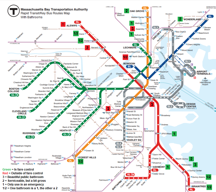
Now that map exists! A female friend and I went around the whole system to every station with fare control snapping photos of and taking notes about all the bathrooms we could find. I then compiled them into an interactive map (with lots of info about each one) and a cobbled-together MS Paint version of the official MBTA map (in case you really gotta go and don’t want to futz around with that interactive map stuff). Here’s the diagrammatic one (I’ll explain the icons in more detail below):
And here’s the interactive Google map (or click here, which seems to work a lot better):
Firstly, the colors. Green means that the station is inside fare control, as in you have to be on the paid side of the fare gates in order to access it. Red is the opposite, meaning that you have to leave the fare gates to get to that bathroom (or if you happen to be in the area – lucky you, it’s a public restroom!).
The numbers represent a somewhat subjective rating system. We scored each bathroom on a 1 to 3 scale, with 3 being the best and 1 being the worst. You might disagree with our scores (everyone’s tolerance for grossness is different), but they should give you a rough idea of what you’re getting yourself into. They also only represent the conditions when we were there – things may have changed since then.
The interactive map adds some more info about each bathroom. You can click on one to see whether it’s single-stall or multiple-stall, whether or not it’s gendered, some notes about its condition, and photos. There’s also a hidden layer of bathrooms that look public but are locked (or at least, they were locked when we came through) – open up the map description and check off that layer if you want to see those.
UPDATE: A note on our rules. I should’ve done a better job explaining which bathrooms we count and which ones we don’t. Our rules were MBTA property only (thus excluding the Macy’s that connects to Downtown Crossing, for example), and bathrooms that can be accessed by the public without needing to ask anyone. There are a lot of unmarked employee bathrooms around the system that the public could use if they asked nicely and the employee on hand was willing to let them, but we didn’t want to count those cases because a number of factors dictate whether or not you can use them. Bathrooms that look public but aren’t appear in the “Locked Bathrooms” layer in the interactive map.
So if you know someone with a tendency to have to use the bathroom often (but let’s be real, we all have emergencies), send this to them! Now they’ll be able to know everywhere on the MBTA where they can go.
Nice job, Miles. In a future version of the map, consider using a comma instead of a slash, e.g. “1,2” to avoid confusion about whether your “1/2” rating means an actual half (0.5) versus what you explain in the key: there are two bathrooms and one is a 1 and the other a 2. (It might also be worth distinguishing “1,2” from “2,1” for those rare cases where the men’s is cleaner, apparently like Porter?)
Noted. Thanks for the feedback!
Thanks for this info. Map does correctly work and open in google maps on my iPhone – but if you know how to save that map into my google maps app ? I’d love to know.
Miles, you need to get AdMob for your site – now. This is pure Boston reblog bait.
Also, the egregious omission of the outbound-only, paid-area bathroom at Central!
It was locked! Maybe that was just when we were there, though.
there is one in Quincy Center although its not always available or clean enough
Where is it? We couldn’t find it.
Right besides the booth and before you go through the fare gate.
Gosh, guess I’ll have to head back. I swear we looked everywhere for one!
Hang on, is it typically unlocked or do you have to ask someone to open it?
Malden station has a bathroom
This map just saved my life, thank you so much!!
I’m so glad!!!
Quincy Center bathrooms are after fare gates on right. NOT marked & not always available best to ask station personal if entering the station. not always clean its one of the black doors on left if coming up from platform
But there are periods when it’s unlocked and you can enter without asking anyone?
It’s always unlocked. But hardly ever cleaned.
Central square outbound platform has one inside fare control but it is absolutely DISGUSTING
Yeah, it was locked when we were there. I’m wondering if we got there too late (around 8:30 PM) for it to be open?
The bathrooms at South Station are beautiful? Are you for real?
“Beautiful public restroom.” As in, “beautiful as far as public restrooms go.” Certainly isn’t perfect, but I’ll take it over most other public restrooms.
The bathrooms south station for example the ladies bathroom is very filthy with 2 or 3 clean stalls.
My boyfriend says mens bathroom is very dirty and gross
THere’s one at Malden Station too, I think it’s a 1. But usually only the staff use it, but they may let a regular person use it in an emegency. So definietely a 1. I think it’s outside the fare control, too. Note that I do NOT recommend anyone try to use it as offically it’s staff only.
Yeah, our rule was only counting bathrooms that are open to the public without having to ask anyone.
Fair enough. I’d probably rank Malden’s restroom a 1 anyway, just judging by the people that they actually grant permission for it…But that is a good rule on your part to only include publicly available ones.
Riverside has two bathrooms. One is in the GO Bus station, and the other is across from the ticket machines right outside fare control and I think may technically be for staff, but they definitely let customers use it because I saw several people using it (an employee let them in) when I was there Saturday. Both are 2s, by the way.
Yeah, we put those both in the “locked bathrooms” layer in the interactive map. GoBus makes it painfully obvious that its bathrooms are for customers only, with signs plastered everywhere saying as much, while the ones at Riverside are based on the employee. When I was there, he wouldn’t let us use it.
Off-topic note: How deep is your backlog, and now that (I assume) you’re back in Philly, how often can you post?
The answer to the backlog question is frankly a frightening one: I’m about a year and three months in the hole right now, as far as Boston content goes. But on the plus side, I’ve had a lot of free time so far, and I’ve got a queue of posts ready to publish for the first time in quite a while!
Wow, that’s great! Are you publishing them all at once or spread out?
Wow that’s great! Are you posting it all at once or spread out over time.
For now my goal is daily (we’ll see how long I can keep that up), but if I ever get a long enough queue, I could try twice-daily. No promises, though, and homework could (will) ramp up as the semester continues.
Will there be a post later today?
Yes, of course.
Malden has a bathroom
We couldn’t find it. I’m pretty sure it’s employees-only.
Neat map, but the red and green are a bit tough to distinguish as I have moderate colorblindness. I’d like for them to be more distinct, such as one of the two colors being blue (many color blind people have trouble with certain shades of red and green), or just having one color be dark gray while one is light gray.
Good point, and definitely noted if I update the map.
Just used JFK today. Yes it’s pretty nasty but I was in real need so thank you!
Hooray! I’m glad this was useful to someone!
amidst coronavirus, just wanted to say how remarkably helpful this intel was. got off at JFK/UMass and was able to use the bathroom without having to leave the station, and continue on to Shawmut. thanks so much for compiling this!
Good to hear the T is still keeping its bathrooms open – especially in the pandemic, it’s so hard to find public restrooms! Glad this was helpful, thank you!
This page is awesome. YOU are Awesome!
Thank you 🙂
I found this useful today . Pleasantly surprised it was exactly where & as you said.
Thanks!
I just moved to Boston and have IBD. You have no idea how much I appreciate you making this. Thank you!
I’m sure there’s a restroom at tufts medical center because I remember seeing a door with restroom on it but idk if it really is one
Oak Grove bathroom locked yesterday :0(
This is great since I travel as a disabled customer on the T! Had no idea that restrooms existed in many of these stations. Great job!